You are here: Home > Network List > US - United States National Seismic Network Stations List
> Station AMTX Amarillo, Texas, USA > Earthquake Result Viewer
AMTX Amarillo, Texas, USA - Earthquake Result Viewer
| Earthquake location: |
Fiji Islands Region |
| Earthquake latitude/longitude: |
-18.2/-179.7 |
| Earthquake time(UTC): |
2018/09/06 (249) 16:31:33 GMT |
| Earthquake Depth: |
644 km |
| Earthquake Magnitude: |
5.5 mb |
| Earthquake Catalog/Contributor: |
NEIC PDE/us |
|
| Network: |
US United States National Seismic Network |
| Station: |
AMTX Amarillo, Texas, USA |
| Lat/Lon: |
34.53 N/101.41 W |
| Elevation: |
1010 m |
|
| Distance: |
90.9 deg |
| Az: |
53.958 deg |
| Baz: |
248.62 deg |
| Ray Param: |
0.041260928 |
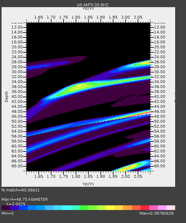
| Estimated Moho Depth: |
46.75 km |
| Estimated Crust Vp/Vs: |
2.08 |
| Assumed Crust Vp: |
6.426 km/s |
| Estimated Crust Vs: |
3.086 km/s |
| Estimated Crust Poisson's Ratio: |
0.35 |
|
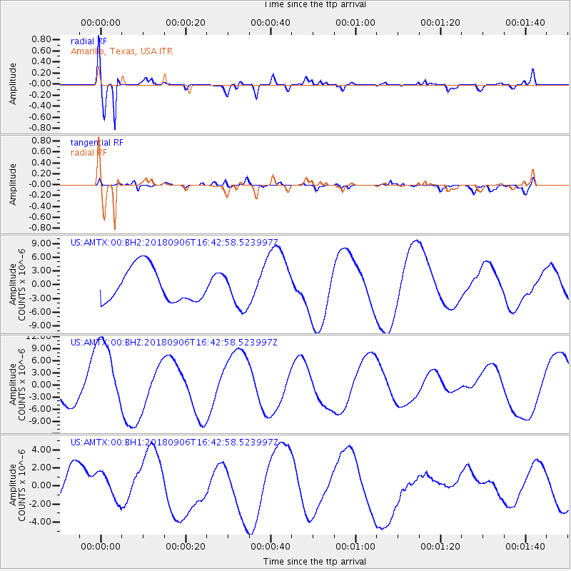
| Radial Match: |
90.06631 % |
| Radial Bump: |
400 |
| Transverse Match: |
38.703453 % |
| Transverse Bump: |
400 |
| SOD ConfigId: |
2825771 |
| Insert Time: |
2018-09-20 16:37:01.540 +0000 |
| GWidth: |
2.5 |
| Max Bumps: |
400 |
| Tol: |
0.001 |
|
Signal To Noise
| Channel | StoN | STA | LTA |
| US:AMTX:00:BHZ:20180906T16:42:58.523997Z | 3.1161063 | 9.472211E-6 | 3.0397584E-6 |
| US:AMTX:00:BH1:20180906T16:42:58.523997Z | 0.5692856 | 1.671114E-6 | 2.935458E-6 |
| US:AMTX:00:BH2:20180906T16:42:58.523997Z | 1.120048 | 4.114594E-6 | 3.6735871E-6 |
| Arrivals |
| Ps | 8.0 SECOND |
| PpPs | 22 SECOND |
| PsPs/PpSs | 30 SECOND |


