You are here: Home > Network List > CC - Cascade Chain Volcano Monitoring Stations List
> Station LSON Lamberson Butte > Earthquake Result Viewer
LSON Lamberson Butte - Earthquake Result Viewer
| Earthquake location: |
Southeast Of Loyalty Islands |
| Earthquake latitude/longitude: |
-21.2/170.1 |
| Earthquake time(UTC): |
2022/09/14 (257) 11:04:07 GMT |
| Earthquake Depth: |
124 km |
| Earthquake Magnitude: |
7.0 Mi |
| Earthquake Catalog/Contributor: |
NEIC PDE/at |
|
| Network: |
CC Cascade Chain Volcano Monitoring |
| Station: |
LSON Lamberson Butte |
| Lat/Lon: |
45.36 N/121.65 W |
| Elevation: |
1881 m |
|
| Distance: |
90.6 deg |
| Az: |
40.912 deg |
| Baz: |
240.086 deg |
| Ray Param: |
0.04165727 |
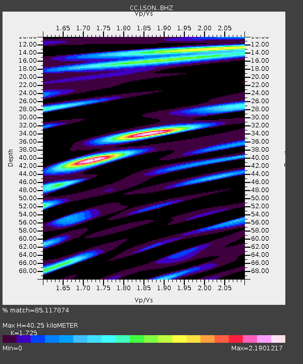
| Estimated Moho Depth: |
40.25 km |
| Estimated Crust Vp/Vs: |
1.73 |
| Assumed Crust Vp: |
6.597 km/s |
| Estimated Crust Vs: |
3.825 km/s |
| Estimated Crust Poisson's Ratio: |
0.25 |
|
| Radial Match: |
85.117874 % |
| Radial Bump: |
400 |
| Transverse Match: |
86.94211 % |
| Transverse Bump: |
400 |
| SOD ConfigId: |
28764291 |
| Insert Time: |
2022-09-28 11:17:09.946 +0000 |
| GWidth: |
2.5 |
| Max Bumps: |
400 |
| Tol: |
0.001 |
|

Signal To Noise
| Channel | StoN | STA | LTA |
| CC:LSON: :BHZ:20220914T11:16:24.23999Z | 56.49912 | 4.618267E-6 | 8.1740524E-8 |
| CC:LSON: :BHN:20220914T11:16:24.23999Z | 10.373181 | 1.2590431E-6 | 1.2137482E-7 |
| CC:LSON: :BHE:20220914T11:16:24.23999Z | 37.35644 | 2.9191706E-6 | 7.81437E-8 |
| Arrivals |
| Ps | 4.5 SECOND |
| PpPs | 16 SECOND |
| PsPs/PpSs | 21 SECOND |


