You are here: Home > Network List > CC - Cascade Chain Volcano Monitoring Stations List
> Station SHRK Shell Rock, OR, USA > Earthquake Result Viewer
SHRK Shell Rock, OR, USA - Earthquake Result Viewer
| Earthquake location: |
Southeast Of Loyalty Islands |
| Earthquake latitude/longitude: |
-21.2/170.1 |
| Earthquake time(UTC): |
2022/09/14 (257) 11:04:07 GMT |
| Earthquake Depth: |
124 km |
| Earthquake Magnitude: |
7.0 Mi |
| Earthquake Catalog/Contributor: |
NEIC PDE/at |
|
| Network: |
CC Cascade Chain Volcano Monitoring |
| Station: |
SHRK Shell Rock, OR, USA |
| Lat/Lon: |
45.46 N/121.53 W |
| Elevation: |
1319 m |
|
| Distance: |
90.8 deg |
| Az: |
40.863 deg |
| Baz: |
240.171 deg |
| Ray Param: |
0.041644342 |
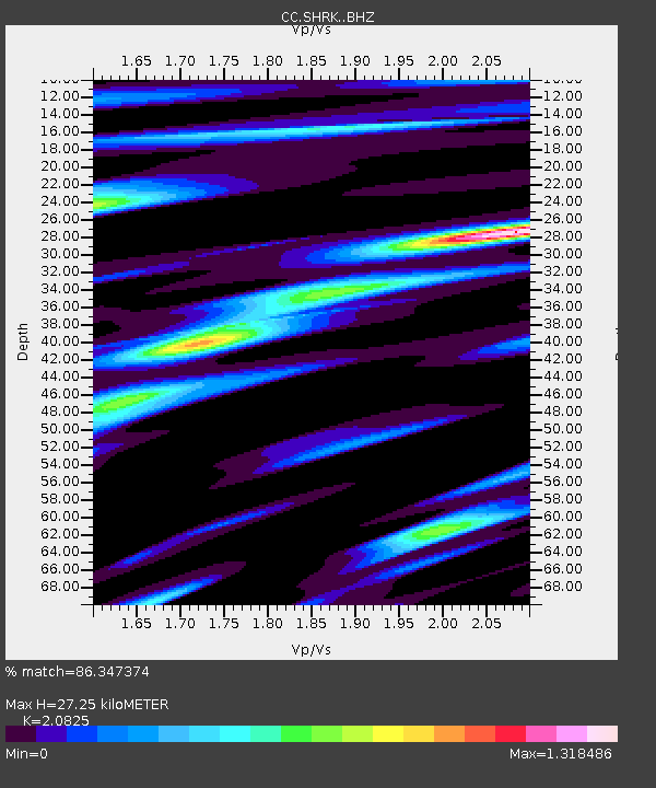
| Estimated Moho Depth: |
27.25 km |
| Estimated Crust Vp/Vs: |
2.08 |
| Assumed Crust Vp: |
6.597 km/s |
| Estimated Crust Vs: |
3.168 km/s |
| Estimated Crust Poisson's Ratio: |
0.35 |
|
| Radial Match: |
86.347374 % |
| Radial Bump: |
400 |
| Transverse Match: |
73.32376 % |
| Transverse Bump: |
400 |
| SOD ConfigId: |
28764291 |
| Insert Time: |
2022-09-28 11:17:34.995 +0000 |
| GWidth: |
2.5 |
| Max Bumps: |
400 |
| Tol: |
0.001 |
|

Signal To Noise
| Channel | StoN | STA | LTA |
| CC:SHRK: :BHZ:20220914T11:16:24.820007Z | 38.53345 | 3.4522848E-6 | 8.959189E-8 |
| CC:SHRK: :BHN:20220914T11:16:24.820007Z | 5.568585 | 6.25407E-7 | 1.1230986E-7 |
| CC:SHRK: :BHE:20220914T11:16:24.820007Z | 7.182349 | 1.0175874E-6 | 1.416789E-7 |
| Arrivals |
| Ps | 4.6 SECOND |
| PpPs | 12 SECOND |
| PsPs/PpSs | 17 SECOND |


