You are here: Home > Network List > CC - Cascade Chain Volcano Monitoring Stations List
> Station HOA Hoala > Earthquake Result Viewer
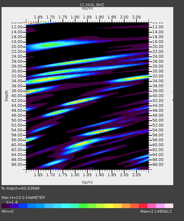
HOA Hoala - Earthquake Result Viewer
| Earthquake location: |
Southeast Of Loyalty Islands |
| Earthquake latitude/longitude: |
-21.2/170.1 |
| Earthquake time(UTC): |
2022/09/14 (257) 11:04:07 GMT |
| Earthquake Depth: |
124 km |
| Earthquake Magnitude: |
7.0 Mi |
| Earthquake Catalog/Contributor: |
NEIC PDE/at |
|
| Network: |
CC Cascade Chain Volcano Monitoring |
| Station: |
HOA Hoala |
| Lat/Lon: |
46.24 N/122.19 W |
| Elevation: |
1151 m |
|
| Distance: |
90.8 deg |
| Az: |
39.958 deg |
| Baz: |
239.709 deg |
| Ray Param: |
0.041645583 |
| Estimated Moho Depth: |
10.0 km |
| Estimated Crust Vp/Vs: |
1.60 |
| Assumed Crust Vp: |
6.566 km/s |
| Estimated Crust Vs: |
4.104 km/s |
| Estimated Crust Poisson's Ratio: |
0.18 |
|
| Radial Match: |
80.83969 % |
| Radial Bump: |
400 |
| Transverse Match: |
78.10349 % |
| Transverse Bump: |
400 |
| SOD ConfigId: |
28764291 |
| Insert Time: |
2022-09-28 11:18:02.453 +0000 |
| GWidth: |
2.5 |
| Max Bumps: |
400 |
| Tol: |
0.001 |
|

Signal To Noise
| Channel | StoN | STA | LTA |
| CC:HOA: :BHZ:20220914T11:16:24.76001Z | 41.53619 | 4.1127196E-6 | 9.901533E-8 |
| CC:HOA: :BHN:20220914T11:16:24.76001Z | 23.172604 | 3.465922E-6 | 1.4956981E-7 |
| CC:HOA: :BHE:20220914T11:16:24.76001Z | 19.056839 | 2.7491305E-6 | 1.4425953E-7 |
| Arrivals |
| Ps | 0.9 SECOND |
| PpPs | 3.9 SECOND |
| PsPs/PpSs | 4.8 SECOND |


