You are here: Home > Network List > CI - Caltech Regional Seismic Network Stations List
> Station FMP Fort MacArthur Park, Pt. Fermin San Pedro, CA, USA > Earthquake Result Viewer
FMP Fort MacArthur Park, Pt. Fermin San Pedro, CA, USA - Earthquake Result Viewer
| Earthquake location: |
Southeast Of Loyalty Islands |
| Earthquake latitude/longitude: |
-21.2/170.1 |
| Earthquake time(UTC): |
2022/09/14 (257) 11:04:07 GMT |
| Earthquake Depth: |
124 km |
| Earthquake Magnitude: |
7.0 Mi |
| Earthquake Catalog/Contributor: |
NEIC PDE/at |
|
| Network: |
CI Caltech Regional Seismic Network |
| Station: |
FMP Fort MacArthur Park, Pt. Fermin San Pedro, CA, USA |
| Lat/Lon: |
33.71 N/118.29 W |
| Elevation: |
89 m |
|
| Distance: |
87.3 deg |
| Az: |
52.357 deg |
| Baz: |
242.429 deg |
| Ray Param: |
0.043148372 |
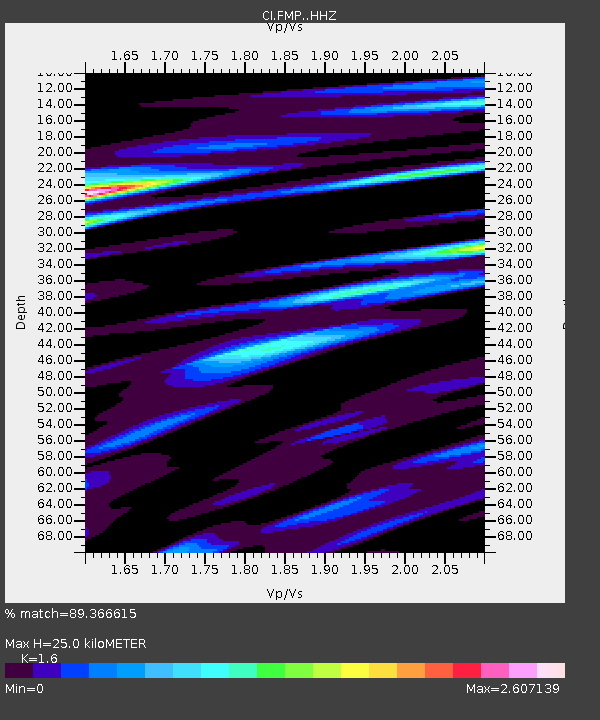
| Estimated Moho Depth: |
25.0 km |
| Estimated Crust Vp/Vs: |
1.60 |
| Assumed Crust Vp: |
6.048 km/s |
| Estimated Crust Vs: |
3.78 km/s |
| Estimated Crust Poisson's Ratio: |
0.18 |
|
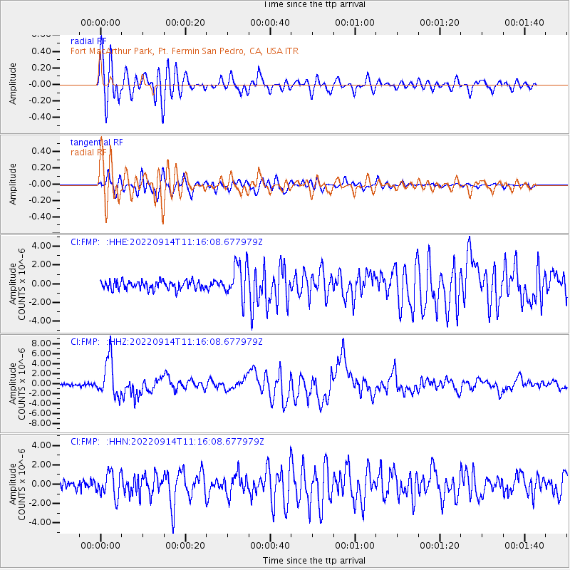
| Radial Match: |
89.366615 % |
| Radial Bump: |
400 |
| Transverse Match: |
85.343094 % |
| Transverse Bump: |
400 |
| SOD ConfigId: |
28764291 |
| Insert Time: |
2022-09-28 11:18:48.895 +0000 |
| GWidth: |
2.5 |
| Max Bumps: |
400 |
| Tol: |
0.001 |
|
Signal To Noise
| Channel | StoN | STA | LTA |
| CI:FMP: :HHZ:20220914T11:16:08.677979Z | 18.33342 | 3.9528686E-6 | 2.1560999E-7 |
| CI:FMP: :HHN:20220914T11:16:08.677979Z | 2.661261 | 1.2932862E-6 | 4.859674E-7 |
| CI:FMP: :HHE:20220914T11:16:08.677979Z | 4.2652845 | 1.918753E-6 | 4.498535E-7 |
| Arrivals |
| Ps | 2.5 SECOND |
| PpPs | 11 SECOND |
| PsPs/PpSs | 13 SECOND |


