You are here: Home > Network List > CI - Caltech Regional Seismic Network Stations List
> Station SMM Simmler, CA, USA > Earthquake Result Viewer
SMM Simmler, CA, USA - Earthquake Result Viewer
| Earthquake location: |
Southeast Of Loyalty Islands |
| Earthquake latitude/longitude: |
-21.2/170.1 |
| Earthquake time(UTC): |
2022/09/14 (257) 11:04:07 GMT |
| Earthquake Depth: |
124 km |
| Earthquake Magnitude: |
7.0 Mi |
| Earthquake Catalog/Contributor: |
NEIC PDE/at |
|
| Network: |
CI Caltech Regional Seismic Network |
| Station: |
SMM Simmler, CA, USA |
| Lat/Lon: |
35.31 N/120.00 W |
| Elevation: |
599 m |
|
| Distance: |
86.8 deg |
| Az: |
50.283 deg |
| Baz: |
241.363 deg |
| Ray Param: |
0.04349624 |
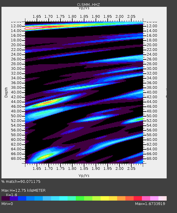
| Estimated Moho Depth: |
12.75 km |
| Estimated Crust Vp/Vs: |
1.60 |
| Assumed Crust Vp: |
6.1 km/s |
| Estimated Crust Vs: |
3.812 km/s |
| Estimated Crust Poisson's Ratio: |
0.18 |
|
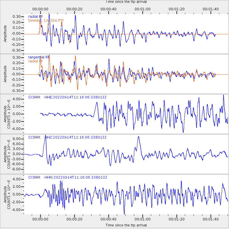
| Radial Match: |
90.071175 % |
| Radial Bump: |
400 |
| Transverse Match: |
85.44577 % |
| Transverse Bump: |
400 |
| SOD ConfigId: |
28764291 |
| Insert Time: |
2022-09-28 11:20:02.400 +0000 |
| GWidth: |
2.5 |
| Max Bumps: |
400 |
| Tol: |
0.001 |
|
Signal To Noise
| Channel | StoN | STA | LTA |
| CI:SMM: :HHZ:20220914T11:16:06.338013Z | 37.407078 | 4.9110563E-6 | 1.3128682E-7 |
| CI:SMM: :HHN:20220914T11:16:06.338013Z | 3.701169 | 7.125149E-7 | 1.9251077E-7 |
| CI:SMM: :HHE:20220914T11:16:06.338013Z | 6.8711877 | 1.5101174E-6 | 2.197753E-7 |
| Arrivals |
| Ps | 1.3 SECOND |
| PpPs | 5.3 SECOND |
| PsPs/PpSs | 6.6 SECOND |


