You are here: Home > Network List > CN - Canadian National Seismograph Network Stations List
> Station PACB Port Alice, BC, CA > Earthquake Result Viewer
PACB Port Alice, BC, CA - Earthquake Result Viewer
| Earthquake location: |
Southeast Of Loyalty Islands |
| Earthquake latitude/longitude: |
-21.2/170.1 |
| Earthquake time(UTC): |
2022/09/14 (257) 11:04:07 GMT |
| Earthquake Depth: |
124 km |
| Earthquake Magnitude: |
7.0 Mi |
| Earthquake Catalog/Contributor: |
NEIC PDE/at |
|
| Network: |
CN Canadian National Seismograph Network |
| Station: |
PACB Port Alice, BC, CA |
| Lat/Lon: |
50.44 N/127.49 W |
| Elevation: |
24 m |
|
| Distance: |
90.0 deg |
| Az: |
34.524 deg |
| Baz: |
235.793 deg |
| Ray Param: |
0.041709177 |
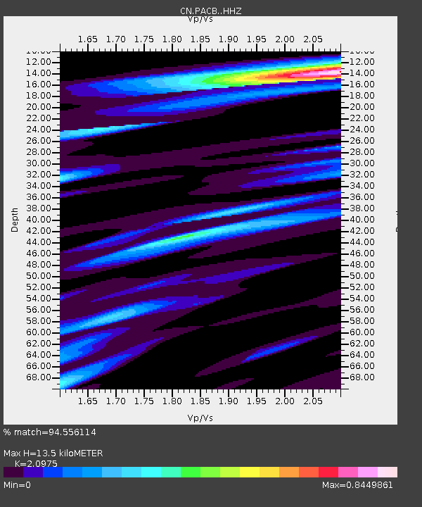
| Estimated Moho Depth: |
13.5 km |
| Estimated Crust Vp/Vs: |
2.10 |
| Assumed Crust Vp: |
6.545 km/s |
| Estimated Crust Vs: |
3.121 km/s |
| Estimated Crust Poisson's Ratio: |
0.35 |
|
| Radial Match: |
94.556114 % |
| Radial Bump: |
344 |
| Transverse Match: |
85.535065 % |
| Transverse Bump: |
400 |
| SOD ConfigId: |
28764291 |
| Insert Time: |
2022-09-28 11:21:33.970 +0000 |
| GWidth: |
2.5 |
| Max Bumps: |
400 |
| Tol: |
0.001 |
|

Signal To Noise
| Channel | StoN | STA | LTA |
| CN:PACB: :HHZ:20220914T11:16:21.27002Z | 35.408516 | 3.8597723E-6 | 1.0900689E-7 |
| CN:PACB: :HHN:20220914T11:16:21.27002Z | 14.534316 | 1.1422114E-6 | 7.858721E-8 |
| CN:PACB: :HHE:20220914T11:16:21.27002Z | 6.9826217 | 7.636152E-7 | 1.09359384E-7 |
| Arrivals |
| Ps | 2.3 SECOND |
| PpPs | 6.3 SECOND |
| PsPs/PpSs | 8.6 SECOND |


