You are here: Home > Network List > CN - Canadian National Seismograph Network Stations List
> Station VDEB Vedder Mountain, BC, CA > Earthquake Result Viewer
VDEB Vedder Mountain, BC, CA - Earthquake Result Viewer
| Earthquake location: |
Southeast Of Loyalty Islands |
| Earthquake latitude/longitude: |
-21.2/170.1 |
| Earthquake time(UTC): |
2022/09/14 (257) 11:04:07 GMT |
| Earthquake Depth: |
124 km |
| Earthquake Magnitude: |
7.0 Mi |
| Earthquake Catalog/Contributor: |
NEIC PDE/at |
|
| Network: |
CN Canadian National Seismograph Network |
| Station: |
VDEB Vedder Mountain, BC, CA |
| Lat/Lon: |
49.06 N/122.06 W |
| Elevation: |
351 m |
|
| Distance: |
92.3 deg |
| Az: |
37.569 deg |
| Baz: |
239.871 deg |
| Ray Param: |
0.04142982 |
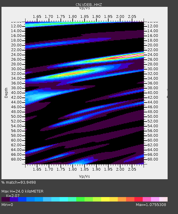
| Estimated Moho Depth: |
24.0 km |
| Estimated Crust Vp/Vs: |
2.07 |
| Assumed Crust Vp: |
6.566 km/s |
| Estimated Crust Vs: |
3.172 km/s |
| Estimated Crust Poisson's Ratio: |
0.35 |
|
| Radial Match: |
93.9498 % |
| Radial Bump: |
383 |
| Transverse Match: |
85.75479 % |
| Transverse Bump: |
400 |
| SOD ConfigId: |
28764291 |
| Insert Time: |
2022-09-28 11:21:53.828 +0000 |
| GWidth: |
2.5 |
| Max Bumps: |
400 |
| Tol: |
0.001 |
|

Signal To Noise
| Channel | StoN | STA | LTA |
| CN:VDEB: :HHZ:20220914T11:16:31.659973Z | 32.046173 | 2.269648E-6 | 7.0824306E-8 |
| CN:VDEB: :HHN:20220914T11:16:31.659973Z | 2.9649832 | 2.540596E-7 | 8.568668E-8 |
| CN:VDEB: :HHE:20220914T11:16:31.659973Z | 11.875672 | 7.8474756E-7 | 6.608026E-8 |
| Arrivals |
| Ps | 4.0 SECOND |
| PpPs | 11 SECOND |
| PsPs/PpSs | 15 SECOND |


