You are here: Home > Network List > PY - PFO Array Stations List
> Station BPH08 Pinon Flat Observatory, CA, USA > Earthquake Result Viewer
BPH08 Pinon Flat Observatory, CA, USA - Earthquake Result Viewer
| Earthquake location: |
Southeast Of Loyalty Islands |
| Earthquake latitude/longitude: |
-21.2/170.1 |
| Earthquake time(UTC): |
2022/09/14 (257) 11:04:07 GMT |
| Earthquake Depth: |
124 km |
| Earthquake Magnitude: |
7.0 Mi |
| Earthquake Catalog/Contributor: |
NEIC PDE/at |
|
| Network: |
PY PFO Array |
| Station: |
BPH08 Pinon Flat Observatory, CA, USA |
| Lat/Lon: |
33.61 N/116.46 W |
| Elevation: |
1300 m |
|
| Distance: |
88.6 deg |
| Az: |
53.144 deg |
| Baz: |
243.47 deg |
| Ray Param: |
0.042181075 |
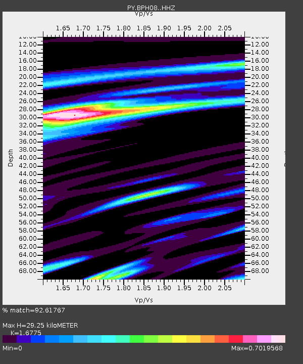
| Estimated Moho Depth: |
29.25 km |
| Estimated Crust Vp/Vs: |
1.68 |
| Assumed Crust Vp: |
6.264 km/s |
| Estimated Crust Vs: |
3.734 km/s |
| Estimated Crust Poisson's Ratio: |
0.22 |
|
| Radial Match: |
92.61767 % |
| Radial Bump: |
253 |
| Transverse Match: |
79.47228 % |
| Transverse Bump: |
400 |
| SOD ConfigId: |
28764291 |
| Insert Time: |
2022-09-28 11:28:51.718 +0000 |
| GWidth: |
2.5 |
| Max Bumps: |
400 |
| Tol: |
0.001 |
|

Signal To Noise
| Channel | StoN | STA | LTA |
| PY:BPH08: :HHZ:20220914T11:16:14.921021Z | 22.113369 | 2.9169535E-6 | 1.3190905E-7 |
| PY:BPH08: :HHN:20220914T11:16:14.921021Z | 3.6387005 | 4.2606234E-7 | 1.170919E-7 |
| PY:BPH08: :HHE:20220914T11:16:14.921021Z | 12.6339855 | 7.1475836E-7 | 5.6574258E-8 |
| Arrivals |
| Ps | 3.2 SECOND |
| PpPs | 12 SECOND |
| PsPs/PpSs | 15 SECOND |


