You are here: Home > Network List > SB - UC Santa Barbara Engineering Seismology Network () Stations List
> Station VAFB2 Taft Rd, Vandenberg AFB, CA, USA > Earthquake Result Viewer
VAFB2 Taft Rd, Vandenberg AFB, CA, USA - Earthquake Result Viewer
| Earthquake location: |
Southeast Of Loyalty Islands |
| Earthquake latitude/longitude: |
-21.2/170.1 |
| Earthquake time(UTC): |
2022/09/14 (257) 11:04:07 GMT |
| Earthquake Depth: |
124 km |
| Earthquake Magnitude: |
7.0 Mi |
| Earthquake Catalog/Contributor: |
NEIC PDE/at |
|
| Network: |
SB UC Santa Barbara Engineering Seismology Network () |
| Station: |
VAFB2 Taft Rd, Vandenberg AFB, CA, USA |
| Lat/Lon: |
34.84 N/120.58 W |
| Elevation: |
91 m |
|
| Distance: |
86.2 deg |
| Az: |
50.461 deg |
| Baz: |
241.038 deg |
| Ray Param: |
0.043967914 |
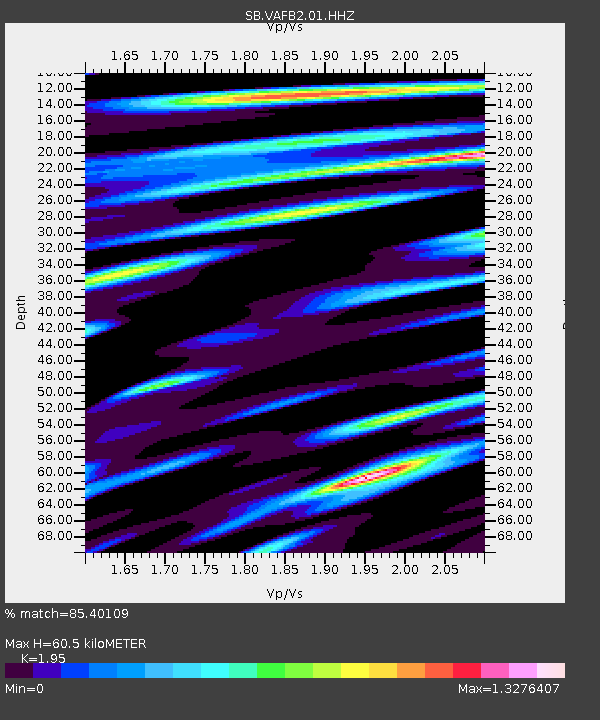
| Estimated Moho Depth: |
60.5 km |
| Estimated Crust Vp/Vs: |
1.95 |
| Assumed Crust Vp: |
6.183 km/s |
| Estimated Crust Vs: |
3.171 km/s |
| Estimated Crust Poisson's Ratio: |
0.32 |
|
| Radial Match: |
85.40109 % |
| Radial Bump: |
400 |
| Transverse Match: |
72.869545 % |
| Transverse Bump: |
400 |
| SOD ConfigId: |
28764291 |
| Insert Time: |
2022-09-28 11:29:54.941 +0000 |
| GWidth: |
2.5 |
| Max Bumps: |
400 |
| Tol: |
0.001 |
|

Signal To Noise
| Channel | StoN | STA | LTA |
| SB:VAFB2:01:HHZ:20220914T11:16:03.195007Z | 12.716157 | 5.115288E-6 | 4.022668E-7 |
| SB:VAFB2:01:HHN:20220914T11:16:03.195007Z | 2.669032 | 1.1829945E-6 | 4.432298E-7 |
| SB:VAFB2:01:HHE:20220914T11:16:03.195007Z | 3.9778414 | 1.8428985E-6 | 4.6329112E-7 |
| Arrivals |
| Ps | 9.5 SECOND |
| PpPs | 28 SECOND |
| PsPs/PpSs | 38 SECOND |


