You are here: Home > Network List > UO - University of Oregon Regional Network Stations List
> Station VINO Umpqua, OR, USA > Earthquake Result Viewer
VINO Umpqua, OR, USA - Earthquake Result Viewer
| Earthquake location: |
Southeast Of Loyalty Islands |
| Earthquake latitude/longitude: |
-21.2/170.1 |
| Earthquake time(UTC): |
2022/09/14 (257) 11:04:07 GMT |
| Earthquake Depth: |
124 km |
| Earthquake Magnitude: |
7.0 Mi |
| Earthquake Catalog/Contributor: |
NEIC PDE/at |
|
| Network: |
UO University of Oregon Regional Network |
| Station: |
VINO Umpqua, OR, USA |
| Lat/Lon: |
43.43 N/123.42 W |
| Elevation: |
319 m |
|
| Distance: |
88.6 deg |
| Az: |
41.929 deg |
| Baz: |
238.856 deg |
| Ray Param: |
0.042229414 |
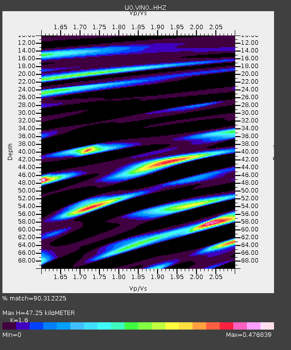
| Estimated Moho Depth: |
47.25 km |
| Estimated Crust Vp/Vs: |
1.60 |
| Assumed Crust Vp: |
6.522 km/s |
| Estimated Crust Vs: |
4.076 km/s |
| Estimated Crust Poisson's Ratio: |
0.18 |
|
| Radial Match: |
90.312225 % |
| Radial Bump: |
400 |
| Transverse Match: |
84.34767 % |
| Transverse Bump: |
400 |
| SOD ConfigId: |
28764291 |
| Insert Time: |
2022-09-28 11:31:57.691 +0000 |
| GWidth: |
2.5 |
| Max Bumps: |
400 |
| Tol: |
0.001 |
|

Signal To Noise
| Channel | StoN | STA | LTA |
| UO:VINO: :HHZ:20220914T11:16:14.599976Z | 41.800503 | 3.7280015E-6 | 8.918556E-8 |
| UO:VINO: :HHN:20220914T11:16:14.599976Z | 4.55499 | 8.021473E-7 | 1.7610297E-7 |
| UO:VINO: :HHE:20220914T11:16:14.599976Z | 6.445811 | 5.3880655E-7 | 8.359019E-8 |
| Arrivals |
| Ps | 4.5 SECOND |
| PpPs | 18 SECOND |
| PsPs/PpSs | 23 SECOND |


