You are here: Home > Network List > US - United States National Seismic Network Stations List
> Station BOZ Bozeman, Montana, USA > Earthquake Result Viewer
BOZ Bozeman, Montana, USA - Earthquake Result Viewer
| Earthquake location: |
Southeast Of Loyalty Islands |
| Earthquake latitude/longitude: |
-21.2/170.1 |
| Earthquake time(UTC): |
2022/09/14 (257) 11:04:07 GMT |
| Earthquake Depth: |
124 km |
| Earthquake Magnitude: |
7.0 Mi |
| Earthquake Catalog/Contributor: |
NEIC PDE/at |
|
| Network: |
US United States National Seismic Network |
| Station: |
BOZ Bozeman, Montana, USA |
| Lat/Lon: |
45.65 N/111.63 W |
| Elevation: |
1589 m |
|
| Distance: |
97.1 deg |
| Az: |
43.796 deg |
| Baz: |
247.023 deg |
| Ray Param: |
0.04022506 |
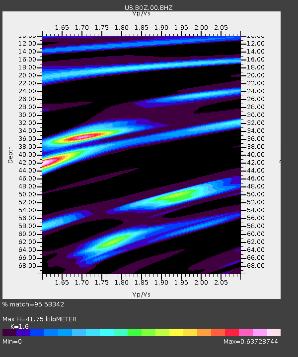
| Estimated Moho Depth: |
41.75 km |
| Estimated Crust Vp/Vs: |
1.60 |
| Assumed Crust Vp: |
6.35 km/s |
| Estimated Crust Vs: |
3.969 km/s |
| Estimated Crust Poisson's Ratio: |
0.18 |
|
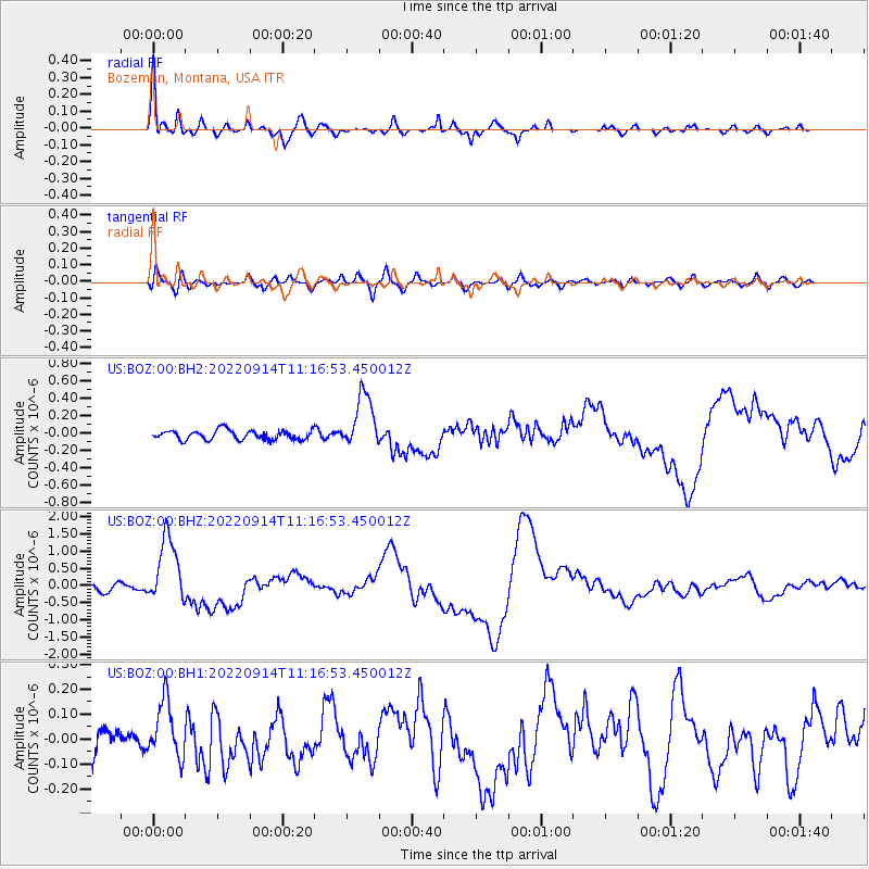
| Radial Match: |
95.58342 % |
| Radial Bump: |
400 |
| Transverse Match: |
76.534485 % |
| Transverse Bump: |
400 |
| SOD ConfigId: |
28764291 |
| Insert Time: |
2022-09-28 11:32:21.709 +0000 |
| GWidth: |
2.5 |
| Max Bumps: |
400 |
| Tol: |
0.001 |
|
Signal To Noise
| Channel | StoN | STA | LTA |
| US:BOZ:00:BHZ:20220914T11:16:53.450012Z | 12.453756 | 9.774476E-7 | 7.8486174E-8 |
| US:BOZ:00:BH1:20220914T11:16:53.450012Z | 2.2229497 | 1.1601737E-7 | 5.2190728E-8 |
| US:BOZ:00:BH2:20220914T11:16:53.450012Z | 5.731286 | 3.124615E-7 | 5.451857E-8 |
| Arrivals |
| Ps | 4.0 SECOND |
| PpPs | 17 SECOND |
| PsPs/PpSs | 21 SECOND |


