You are here: Home > Network List > UU - University of Utah Regional Network Stations List
> Station FOR1 Milford Southwest, UT, USA > Earthquake Result Viewer
FOR1 Milford Southwest, UT, USA - Earthquake Result Viewer
| Earthquake location: |
Southeast Of Loyalty Islands |
| Earthquake latitude/longitude: |
-21.2/170.1 |
| Earthquake time(UTC): |
2022/09/14 (257) 11:04:07 GMT |
| Earthquake Depth: |
124 km |
| Earthquake Magnitude: |
7.0 Mi |
| Earthquake Catalog/Contributor: |
NEIC PDE/at |
|
| Network: |
UU University of Utah Regional Network |
| Station: |
FOR1 Milford Southwest, UT, USA |
| Lat/Lon: |
38.37 N/113.09 W |
| Elevation: |
1642 m |
|
| Distance: |
93.1 deg |
| Az: |
50.037 deg |
| Baz: |
245.488 deg |
| Ray Param: |
0.041256513 |
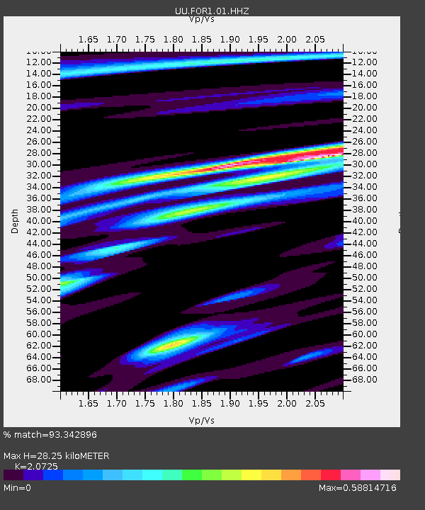
| Estimated Moho Depth: |
28.25 km |
| Estimated Crust Vp/Vs: |
2.07 |
| Assumed Crust Vp: |
6.276 km/s |
| Estimated Crust Vs: |
3.028 km/s |
| Estimated Crust Poisson's Ratio: |
0.35 |
|
| Radial Match: |
93.342896 % |
| Radial Bump: |
396 |
| Transverse Match: |
75.13973 % |
| Transverse Bump: |
400 |
| SOD ConfigId: |
28764291 |
| Insert Time: |
2022-09-28 11:32:49.708 +0000 |
| GWidth: |
2.5 |
| Max Bumps: |
400 |
| Tol: |
0.001 |
|

Signal To Noise
| Channel | StoN | STA | LTA |
| UU:FOR1:01:HHZ:20220914T11:16:35.744995Z | 33.51846 | 5.2152075E-8 | 1.555921E-9 |
| UU:FOR1:01:HHN:20220914T11:16:35.744995Z | 3.9121976 | 7.963414E-9 | 2.0355346E-9 |
| UU:FOR1:01:HHE:20220914T11:16:35.744995Z | 7.060711 | 1.6135274E-8 | 2.2852196E-9 |
| Arrivals |
| Ps | 4.9 SECOND |
| PpPs | 14 SECOND |
| PsPs/PpSs | 19 SECOND |


