You are here: Home > Network List > UW - Pacific Northwest Regional Seismic Network Stations List
> Station DAVN Davenport, WA, USA > Earthquake Result Viewer
DAVN Davenport, WA, USA - Earthquake Result Viewer
| Earthquake location: |
Southeast Of Loyalty Islands |
| Earthquake latitude/longitude: |
-21.2/170.1 |
| Earthquake time(UTC): |
2022/09/14 (257) 11:04:07 GMT |
| Earthquake Depth: |
124 km |
| Earthquake Magnitude: |
7.0 Mi |
| Earthquake Catalog/Contributor: |
NEIC PDE/at |
|
| Network: |
UW Pacific Northwest Regional Seismic Network |
| Station: |
DAVN Davenport, WA, USA |
| Lat/Lon: |
47.80 N/118.27 W |
| Elevation: |
483 m |
|
| Distance: |
93.9 deg |
| Az: |
39.886 deg |
| Baz: |
242.57 deg |
| Ray Param: |
0.04109966 |
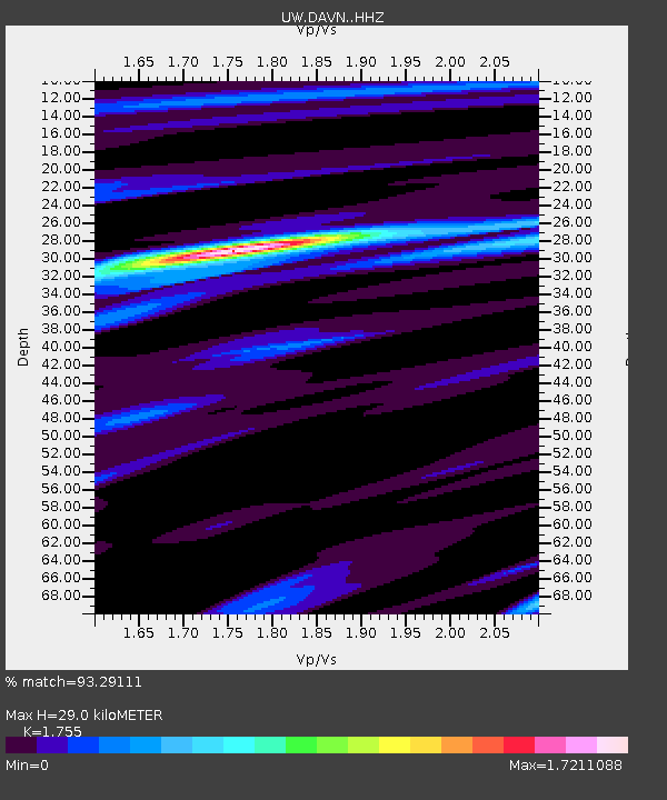
| Estimated Moho Depth: |
29.0 km |
| Estimated Crust Vp/Vs: |
1.75 |
| Assumed Crust Vp: |
6.419 km/s |
| Estimated Crust Vs: |
3.658 km/s |
| Estimated Crust Poisson's Ratio: |
0.26 |
|
| Radial Match: |
93.29111 % |
| Radial Bump: |
288 |
| Transverse Match: |
99.907646 % |
| Transverse Bump: |
19 |
| SOD ConfigId: |
28764291 |
| Insert Time: |
2022-09-28 11:33:46.841 +0000 |
| GWidth: |
2.5 |
| Max Bumps: |
400 |
| Tol: |
0.001 |
|

Signal To Noise
| Channel | StoN | STA | LTA |
| UW:DAVN: :HHZ:20220914T11:16:39.000Z | 19.67545 | 1.0425457E-6 | 5.2987136E-8 |
| UW:DAVN: :HHN:20220914T11:16:39.000Z | 23.14802 | 8.711869E-7 | 3.7635484E-8 |
| UW:DAVN: :HHE:20220914T11:16:39.000Z | 2.60652 | 1.386767E-7 | 5.3203774E-8 |
| Arrivals |
| Ps | 3.5 SECOND |
| PpPs | 12 SECOND |
| PsPs/PpSs | 16 SECOND |


