You are here: Home > Network List > UW - Pacific Northwest Regional Seismic Network Stations List
> Station LON Longmire CREST broad-band > Earthquake Result Viewer
LON Longmire CREST broad-band - Earthquake Result Viewer
| Earthquake location: |
Southeast Of Loyalty Islands |
| Earthquake latitude/longitude: |
-21.2/170.1 |
| Earthquake time(UTC): |
2022/09/14 (257) 11:04:07 GMT |
| Earthquake Depth: |
124 km |
| Earthquake Magnitude: |
7.0 Mi |
| Earthquake Catalog/Contributor: |
NEIC PDE/at |
|
| Network: |
UW Pacific Northwest Regional Seismic Network |
| Station: |
LON Longmire CREST broad-band |
| Lat/Lon: |
46.75 N/121.81 W |
| Elevation: |
853 m |
|
| Distance: |
91.2 deg |
| Az: |
39.65 deg |
| Baz: |
239.991 deg |
| Ray Param: |
0.041587736 |
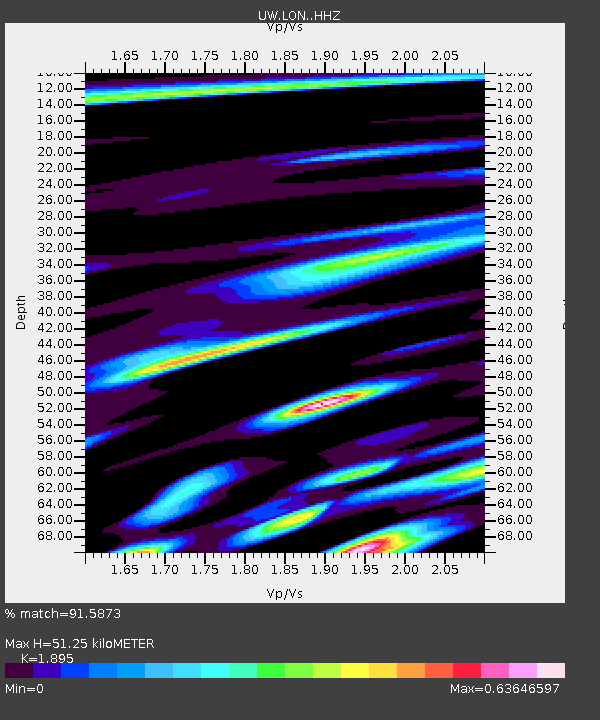
| Estimated Moho Depth: |
51.25 km |
| Estimated Crust Vp/Vs: |
1.89 |
| Assumed Crust Vp: |
6.597 km/s |
| Estimated Crust Vs: |
3.482 km/s |
| Estimated Crust Poisson's Ratio: |
0.31 |
|
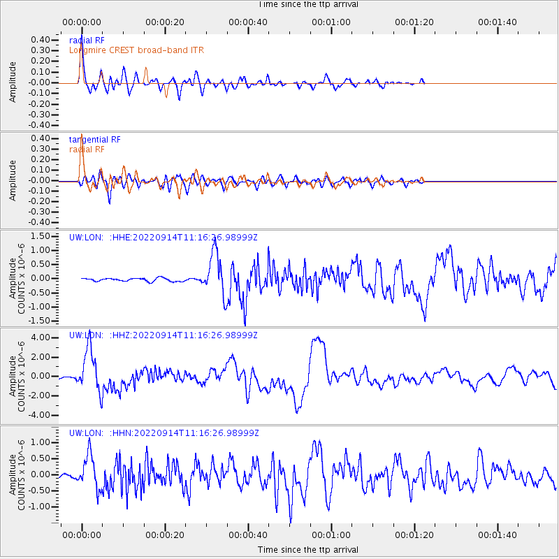
| Radial Match: |
91.5873 % |
| Radial Bump: |
400 |
| Transverse Match: |
75.68239 % |
| Transverse Bump: |
400 |
| SOD ConfigId: |
28764291 |
| Insert Time: |
2022-09-28 11:34:36.487 +0000 |
| GWidth: |
2.5 |
| Max Bumps: |
400 |
| Tol: |
0.001 |
|
Signal To Noise
| Channel | StoN | STA | LTA |
| UW:LON: :HHZ:20220914T11:16:26.98999Z | 38.855953 | 2.2843997E-6 | 5.87915E-8 |
| UW:LON: :HHN:20220914T11:16:26.98999Z | 11.25 | 5.328681E-7 | 4.7366058E-8 |
| UW:LON: :HHE:20220914T11:16:26.98999Z | 13.847497 | 7.611628E-7 | 5.496754E-8 |
| Arrivals |
| Ps | 7.1 SECOND |
| PpPs | 22 SECOND |
| PsPs/PpSs | 29 SECOND |


