You are here: Home > Network List > UW - Pacific Northwest Regional Seismic Network Stations List
> Station YACT Yacolt, WA, USA > Earthquake Result Viewer
YACT Yacolt, WA, USA - Earthquake Result Viewer
| Earthquake location: |
Southeast Of Loyalty Islands |
| Earthquake latitude/longitude: |
-21.2/170.1 |
| Earthquake time(UTC): |
2022/09/14 (257) 11:04:07 GMT |
| Earthquake Depth: |
124 km |
| Earthquake Magnitude: |
7.0 Mi |
| Earthquake Catalog/Contributor: |
NEIC PDE/at |
|
| Network: |
UW Pacific Northwest Regional Seismic Network |
| Station: |
YACT Yacolt, WA, USA |
| Lat/Lon: |
45.93 N/122.42 W |
| Elevation: |
214 m |
|
| Distance: |
90.5 deg |
| Az: |
40.145 deg |
| Baz: |
239.544 deg |
| Ray Param: |
0.041674398 |
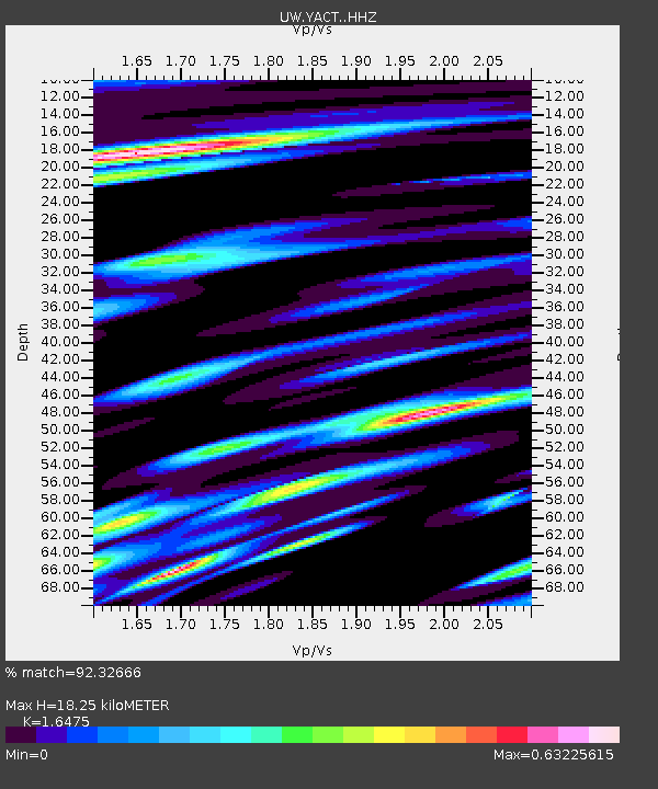
| Estimated Moho Depth: |
18.25 km |
| Estimated Crust Vp/Vs: |
1.65 |
| Assumed Crust Vp: |
6.566 km/s |
| Estimated Crust Vs: |
3.986 km/s |
| Estimated Crust Poisson's Ratio: |
0.21 |
|
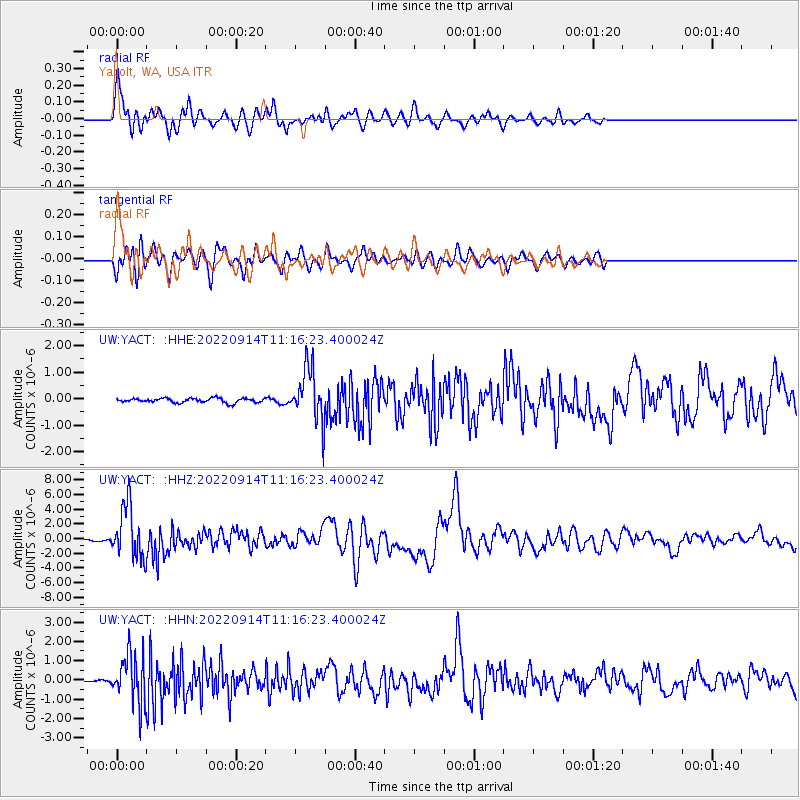
| Radial Match: |
92.32666 % |
| Radial Bump: |
400 |
| Transverse Match: |
78.838455 % |
| Transverse Bump: |
400 |
| SOD ConfigId: |
28764291 |
| Insert Time: |
2022-09-28 11:35:56.833 +0000 |
| GWidth: |
2.5 |
| Max Bumps: |
400 |
| Tol: |
0.001 |
|
Signal To Noise
| Channel | StoN | STA | LTA |
| UW:YACT: :HHZ:20220914T11:16:23.400024Z | 42.586216 | 3.5904468E-6 | 8.431007E-8 |
| UW:YACT: :HHN:20220914T11:16:23.400024Z | 23.694145 | 1.256555E-6 | 5.30323E-8 |
| UW:YACT: :HHE:20220914T11:16:23.400024Z | 12.142506 | 9.949432E-7 | 8.193887E-8 |
| Arrivals |
| Ps | 1.8 SECOND |
| PpPs | 7.2 SECOND |
| PsPs/PpSs | 9.0 SECOND |


