You are here: Home > Network List > UW - Pacific Northwest Regional Seismic Network Stations List
> Station YPT Yellepit > Earthquake Result Viewer
YPT Yellepit - Earthquake Result Viewer
| Earthquake location: |
Southeast Of Loyalty Islands |
| Earthquake latitude/longitude: |
-21.2/170.1 |
| Earthquake time(UTC): |
2022/09/14 (257) 11:04:07 GMT |
| Earthquake Depth: |
124 km |
| Earthquake Magnitude: |
7.0 Mi |
| Earthquake Catalog/Contributor: |
NEIC PDE/at |
|
| Network: |
UW Pacific Northwest Regional Seismic Network |
| Station: |
YPT Yellepit |
| Lat/Lon: |
46.05 N/118.96 W |
| Elevation: |
330 m |
|
| Distance: |
92.6 deg |
| Az: |
41.22 deg |
| Baz: |
241.993 deg |
| Ray Param: |
0.04136151 |
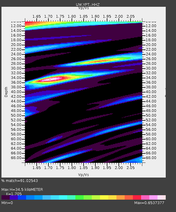
| Estimated Moho Depth: |
34.5 km |
| Estimated Crust Vp/Vs: |
1.71 |
| Assumed Crust Vp: |
6.419 km/s |
| Estimated Crust Vs: |
3.765 km/s |
| Estimated Crust Poisson's Ratio: |
0.24 |
|
| Radial Match: |
91.02543 % |
| Radial Bump: |
363 |
| Transverse Match: |
79.352776 % |
| Transverse Bump: |
400 |
| SOD ConfigId: |
28764291 |
| Insert Time: |
2022-09-28 11:35:58.809 +0000 |
| GWidth: |
2.5 |
| Max Bumps: |
400 |
| Tol: |
0.001 |
|

Signal To Noise
| Channel | StoN | STA | LTA |
| UW:YPT: :HHZ:20220914T11:16:33.359985Z | 31.540325 | 2.2317668E-6 | 7.075916E-8 |
| UW:YPT: :HHN:20220914T11:16:33.359985Z | 7.2397223 | 4.402572E-7 | 6.081134E-8 |
| UW:YPT: :HHE:20220914T11:16:33.359985Z | 9.788388 | 6.4568667E-7 | 6.596455E-8 |
| Arrivals |
| Ps | 3.9 SECOND |
| PpPs | 14 SECOND |
| PsPs/PpSs | 18 SECOND |


