You are here: Home > Network List > UW - Pacific Northwest Regional Seismic Network Stations List
> Station BHAM Bellingham, WA, USA > Earthquake Result Viewer
BHAM Bellingham, WA, USA - Earthquake Result Viewer
| Earthquake location: |
Southeast Of Loyalty Islands |
| Earthquake latitude/longitude: |
-21.2/170.1 |
| Earthquake time(UTC): |
2022/09/14 (257) 11:04:07 GMT |
| Earthquake Depth: |
124 km |
| Earthquake Magnitude: |
7.0 Mi |
| Earthquake Catalog/Contributor: |
NEIC PDE/at |
|
| Network: |
UW Pacific Northwest Regional Seismic Network |
| Station: |
BHAM Bellingham, WA, USA |
| Lat/Lon: |
48.79 N/122.42 W |
| Elevation: |
116 m |
|
| Distance: |
91.9 deg |
| Az: |
37.682 deg |
| Baz: |
239.596 deg |
| Ray Param: |
0.04148797 |
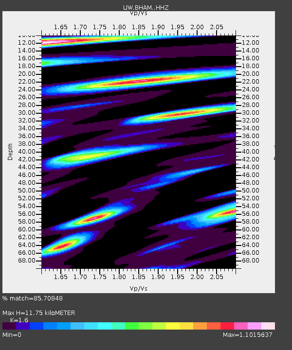
| Estimated Moho Depth: |
11.75 km |
| Estimated Crust Vp/Vs: |
1.60 |
| Assumed Crust Vp: |
6.566 km/s |
| Estimated Crust Vs: |
4.104 km/s |
| Estimated Crust Poisson's Ratio: |
0.18 |
|
| Radial Match: |
85.70848 % |
| Radial Bump: |
400 |
| Transverse Match: |
83.52104 % |
| Transverse Bump: |
400 |
| SOD ConfigId: |
28764291 |
| Insert Time: |
2022-09-28 11:36:21.406 +0000 |
| GWidth: |
2.5 |
| Max Bumps: |
400 |
| Tol: |
0.001 |
|

Signal To Noise
| Channel | StoN | STA | LTA |
| UW:BHAM: :HHZ:20220914T11:16:30.090027Z | 22.008999 | 2.9533926E-6 | 1.3419023E-7 |
| UW:BHAM: :HHN:20220914T11:16:30.090027Z | 2.1630087 | 4.893662E-7 | 2.262433E-7 |
| UW:BHAM: :HHE:20220914T11:16:30.090027Z | 2.971396 | 7.547329E-7 | 2.5399945E-7 |
| Arrivals |
| Ps | 1.1 SECOND |
| PpPs | 4.5 SECOND |
| PsPs/PpSs | 5.6 SECOND |


