You are here: Home > Network List > UW - Pacific Northwest Regional Seismic Network Stations List
> Station BHW Bald Hill, WA, USA > Earthquake Result Viewer
BHW Bald Hill, WA, USA - Earthquake Result Viewer
| Earthquake location: |
Southeast Of Loyalty Islands |
| Earthquake latitude/longitude: |
-21.2/170.1 |
| Earthquake time(UTC): |
2022/09/14 (257) 11:04:07 GMT |
| Earthquake Depth: |
124 km |
| Earthquake Magnitude: |
7.0 Mi |
| Earthquake Catalog/Contributor: |
NEIC PDE/at |
|
| Network: |
UW Pacific Northwest Regional Seismic Network |
| Station: |
BHW Bald Hill, WA, USA |
| Lat/Lon: |
47.84 N/122.03 W |
| Elevation: |
152 m |
|
| Distance: |
91.7 deg |
| Az: |
38.634 deg |
| Baz: |
239.854 deg |
| Ray Param: |
0.04152858 |
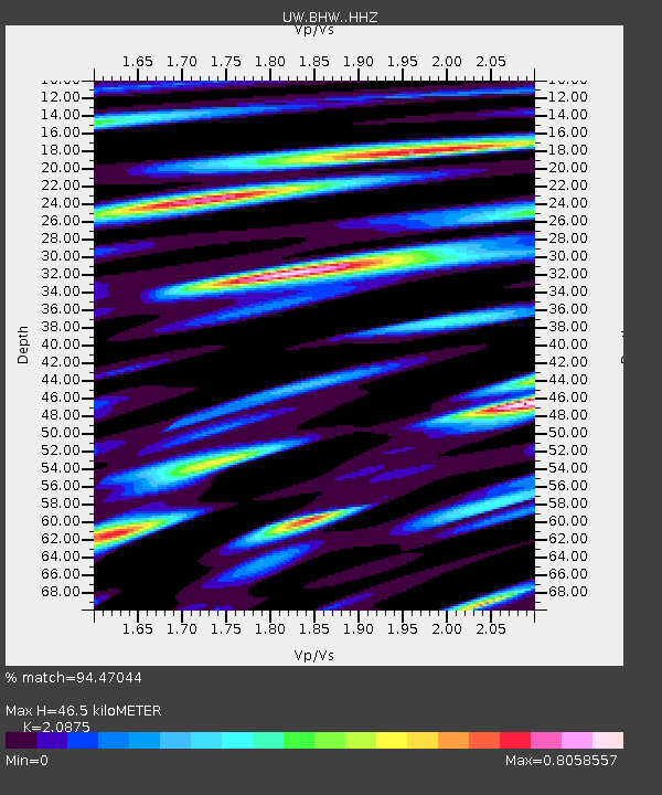
| Estimated Moho Depth: |
46.5 km |
| Estimated Crust Vp/Vs: |
2.09 |
| Assumed Crust Vp: |
6.566 km/s |
| Estimated Crust Vs: |
3.145 km/s |
| Estimated Crust Poisson's Ratio: |
0.35 |
|
| Radial Match: |
94.47044 % |
| Radial Bump: |
400 |
| Transverse Match: |
86.220726 % |
| Transverse Bump: |
400 |
| SOD ConfigId: |
28764291 |
| Insert Time: |
2022-09-28 11:36:24.753 +0000 |
| GWidth: |
2.5 |
| Max Bumps: |
400 |
| Tol: |
0.001 |
|

Signal To Noise
| Channel | StoN | STA | LTA |
| UW:BHW: :HHZ:20220914T11:16:28.900024Z | 29.922245 | 3.008717E-6 | 1.0055117E-7 |
| UW:BHW: :HHN:20220914T11:16:28.900024Z | 5.5544095 | 5.550784E-7 | 9.9934724E-8 |
| UW:BHW: :HHE:20220914T11:16:28.900024Z | 6.670372 | 5.8022954E-7 | 8.6986084E-8 |
| Arrivals |
| Ps | 7.8 SECOND |
| PpPs | 21 SECOND |
| PsPs/PpSs | 29 SECOND |


