You are here: Home > Network List > AK - Alaska Regional Network Stations List
> Station C23K Itkillik River, AK, USA > Earthquake Result Viewer
C23K Itkillik River, AK, USA - Earthquake Result Viewer
| Earthquake location: |
Taiwan |
| Earthquake latitude/longitude: |
23.0/121.2 |
| Earthquake time(UTC): |
2022/09/17 (260) 13:41:21 GMT |
| Earthquake Depth: |
45 km |
| Earthquake Magnitude: |
6.6 Mi |
| Earthquake Catalog/Contributor: |
NEIC PDE/at |
|
| Network: |
AK Alaska Regional Network |
| Station: |
C23K Itkillik River, AK, USA |
| Lat/Lon: |
69.84 N/150.61 W |
| Elevation: |
179 m |
|
| Distance: |
68.0 deg |
| Az: |
21.949 deg |
| Baz: |
276.65 deg |
| Ray Param: |
0.05650208 |
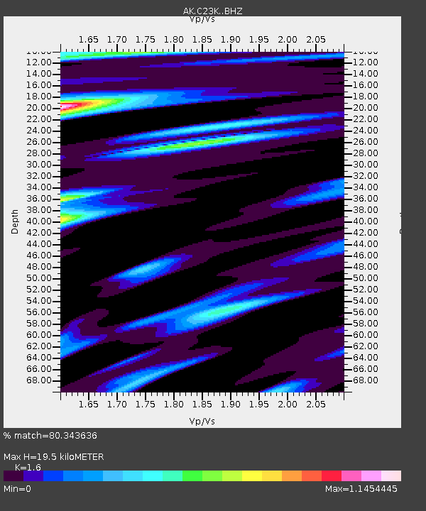
| Estimated Moho Depth: |
19.5 km |
| Estimated Crust Vp/Vs: |
1.60 |
| Assumed Crust Vp: |
6.221 km/s |
| Estimated Crust Vs: |
3.888 km/s |
| Estimated Crust Poisson's Ratio: |
0.18 |
|
| Radial Match: |
80.343636 % |
| Radial Bump: |
389 |
| Transverse Match: |
62.332836 % |
| Transverse Bump: |
400 |
| SOD ConfigId: |
28764291 |
| Insert Time: |
2022-10-01 13:44:57.732 +0000 |
| GWidth: |
2.5 |
| Max Bumps: |
400 |
| Tol: |
0.001 |
|

Signal To Noise
| Channel | StoN | STA | LTA |
| AK:C23K: :BHZ:20220917T13:51:44.73999Z | 3.5134006 | 2.0335517E-6 | 5.7879873E-7 |
| AK:C23K: :BHN:20220917T13:51:44.73999Z | 0.8807161 | 3.6185958E-7 | 4.1086975E-7 |
| AK:C23K: :BHE:20220917T13:51:44.73999Z | 2.1610174 | 1.09616E-6 | 5.0724253E-7 |
| Arrivals |
| Ps | 2.0 SECOND |
| PpPs | 7.8 SECOND |
| PsPs/PpSs | 9.8 SECOND |


