You are here: Home > Network List > AU - Australian Seismological Centre Stations List
> Station KIM01 GSWA station > Earthquake Result Viewer
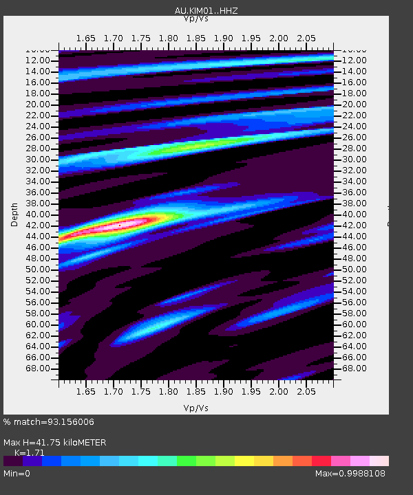
KIM01 GSWA station - Earthquake Result Viewer
| Earthquake location: |
Taiwan |
| Earthquake latitude/longitude: |
23.0/121.2 |
| Earthquake time(UTC): |
2022/09/17 (260) 13:41:21 GMT |
| Earthquake Depth: |
45 km |
| Earthquake Magnitude: |
6.6 Mi |
| Earthquake Catalog/Contributor: |
NEIC PDE/at |
|
| Network: |
AU Australian Seismological Centre |
| Station: |
KIM01 GSWA station |
| Lat/Lon: |
18.62 S/126.86 E |
| Elevation: |
314 m |
|
| Distance: |
41.7 deg |
| Az: |
171.919 deg |
| Baz: |
352.149 deg |
| Ray Param: |
0.07348708 |
| Estimated Moho Depth: |
41.75 km |
| Estimated Crust Vp/Vs: |
1.71 |
| Assumed Crust Vp: |
6.496 km/s |
| Estimated Crust Vs: |
3.799 km/s |
| Estimated Crust Poisson's Ratio: |
0.24 |
|
| Radial Match: |
93.156006 % |
| Radial Bump: |
281 |
| Transverse Match: |
78.00948 % |
| Transverse Bump: |
400 |
| SOD ConfigId: |
28764291 |
| Insert Time: |
2022-10-01 13:49:47.000 +0000 |
| GWidth: |
2.5 |
| Max Bumps: |
400 |
| Tol: |
0.001 |
|

Signal To Noise
| Channel | StoN | STA | LTA |
| AU:KIM01: :HHZ:20220917T13:48:35.250Z | 3.6219609 | 1.0006171E-6 | 2.762639E-7 |
| AU:KIM01: :HHN:20220917T13:48:35.250Z | 3.0620162 | 5.50762E-7 | 1.7986908E-7 |
| AU:KIM01: :HHE:20220917T13:48:35.250Z | 1.3143823 | 1.8280946E-7 | 1.3908394E-7 |
| Arrivals |
| Ps | 4.9 SECOND |
| PpPs | 16 SECOND |
| PsPs/PpSs | 21 SECOND |


