You are here: Home > Network List > AV - Alaska Volcano Observatory Stations List
> Station SPNN North Nagishlamina, Mount Spurr, Alaska > Earthquake Result Viewer
SPNN North Nagishlamina, Mount Spurr, Alaska - Earthquake Result Viewer
| Earthquake location: |
Taiwan |
| Earthquake latitude/longitude: |
23.0/121.2 |
| Earthquake time(UTC): |
2022/09/17 (260) 13:41:21 GMT |
| Earthquake Depth: |
45 km |
| Earthquake Magnitude: |
6.6 Mi |
| Earthquake Catalog/Contributor: |
NEIC PDE/at |
|
| Network: |
AV Alaska Volcano Observatory |
| Station: |
SPNN North Nagishlamina, Mount Spurr, Alaska |
| Lat/Lon: |
61.37 N/152.70 W |
| Elevation: |
1666 m |
|
| Distance: |
68.2 deg |
| Az: |
31.16 deg |
| Baz: |
278.183 deg |
| Ray Param: |
0.056345917 |
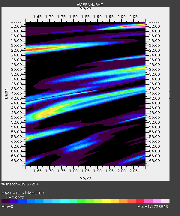
| Estimated Moho Depth: |
11.5 km |
| Estimated Crust Vp/Vs: |
2.10 |
| Assumed Crust Vp: |
6.566 km/s |
| Estimated Crust Vs: |
3.13 km/s |
| Estimated Crust Poisson's Ratio: |
0.35 |
|
| Radial Match: |
89.57294 % |
| Radial Bump: |
400 |
| Transverse Match: |
72.979195 % |
| Transverse Bump: |
400 |
| SOD ConfigId: |
28764291 |
| Insert Time: |
2022-10-01 13:51:13.239 +0000 |
| GWidth: |
2.5 |
| Max Bumps: |
400 |
| Tol: |
0.001 |
|

Signal To Noise
| Channel | StoN | STA | LTA |
| AV:SPNN: :BHZ:20220917T13:51:46.218994Z | 9.059207 | 1.1458486E-6 | 1.2648444E-7 |
| AV:SPNN: :BHN:20220917T13:51:46.218994Z | 1.4154989 | 2.3344907E-7 | 1.6492353E-7 |
| AV:SPNN: :BHE:20220917T13:51:46.218994Z | 3.7903 | 5.235612E-7 | 1.3813188E-7 |
| Arrivals |
| Ps | 2.0 SECOND |
| PpPs | 5.2 SECOND |
| PsPs/PpSs | 7.2 SECOND |


