You are here: Home > Network List > UW - Pacific Northwest Regional Seismic Network Stations List
> Station SAXON Nesset Farm, Saxon, WA, USA > Earthquake Result Viewer
SAXON Nesset Farm, Saxon, WA, USA - Earthquake Result Viewer
| Earthquake location: |
Taiwan |
| Earthquake latitude/longitude: |
23.0/121.2 |
| Earthquake time(UTC): |
2022/09/17 (260) 13:41:21 GMT |
| Earthquake Depth: |
45 km |
| Earthquake Magnitude: |
6.6 Mi |
| Earthquake Catalog/Contributor: |
NEIC PDE/at |
|
| Network: |
UW Pacific Northwest Regional Seismic Network |
| Station: |
SAXON Nesset Farm, Saxon, WA, USA |
| Lat/Lon: |
48.68 N/122.16 W |
| Elevation: |
111 m |
|
| Distance: |
89.0 deg |
| Az: |
36.332 deg |
| Baz: |
304.538 deg |
| Ray Param: |
0.042094026 |
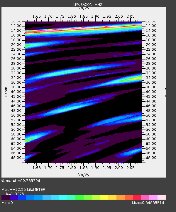
| Estimated Moho Depth: |
12.25 km |
| Estimated Crust Vp/Vs: |
1.93 |
| Assumed Crust Vp: |
6.566 km/s |
| Estimated Crust Vs: |
3.407 km/s |
| Estimated Crust Poisson's Ratio: |
0.32 |
|
| Radial Match: |
90.785706 % |
| Radial Bump: |
400 |
| Transverse Match: |
80.15545 % |
| Transverse Bump: |
400 |
| SOD ConfigId: |
28764291 |
| Insert Time: |
2022-10-01 14:06:21.503 +0000 |
| GWidth: |
2.5 |
| Max Bumps: |
400 |
| Tol: |
0.001 |
|

Signal To Noise
| Channel | StoN | STA | LTA |
| UW:SAXON: :HHZ:20220917T13:53:39.909973Z | 5.397177 | 5.6997345E-7 | 1.0560585E-7 |
| UW:SAXON: :HHN:20220917T13:53:39.909973Z | 1.3305945 | 1.885359E-7 | 1.4169298E-7 |
| UW:SAXON: :HHE:20220917T13:53:39.909973Z | 1.7088366 | 2.4398344E-7 | 1.4277751E-7 |
| Arrivals |
| Ps | 1.8 SECOND |
| PpPs | 5.4 SECOND |
| PsPs/PpSs | 7.1 SECOND |


