You are here: Home > Network List > UW - Pacific Northwest Regional Seismic Network Stations List
> Station CROWN Crown Point, Clallam County, WA, USA > Earthquake Result Viewer
CROWN Crown Point, Clallam County, WA, USA - Earthquake Result Viewer
| Earthquake location: |
Taiwan |
| Earthquake latitude/longitude: |
23.0/121.2 |
| Earthquake time(UTC): |
2022/09/17 (260) 13:41:21 GMT |
| Earthquake Depth: |
45 km |
| Earthquake Magnitude: |
6.6 Mi |
| Earthquake Catalog/Contributor: |
NEIC PDE/at |
|
| Network: |
UW Pacific Northwest Regional Seismic Network |
| Station: |
CROWN Crown Point, Clallam County, WA, USA |
| Lat/Lon: |
48.30 N/124.48 W |
| Elevation: |
399 m |
|
| Distance: |
87.9 deg |
| Az: |
37.504 deg |
| Baz: |
302.838 deg |
| Ray Param: |
0.04288374 |
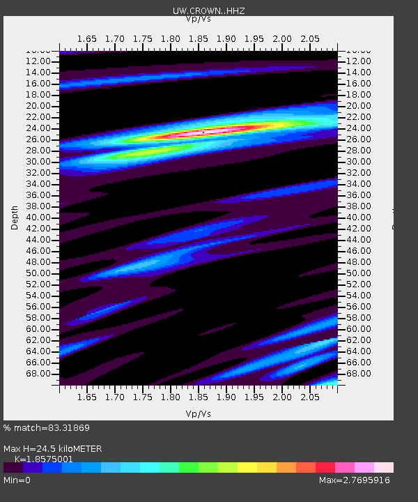
| Estimated Moho Depth: |
24.5 km |
| Estimated Crust Vp/Vs: |
1.86 |
| Assumed Crust Vp: |
6.391 km/s |
| Estimated Crust Vs: |
3.44 km/s |
| Estimated Crust Poisson's Ratio: |
0.30 |
|
| Radial Match: |
83.31869 % |
| Radial Bump: |
330 |
| Transverse Match: |
71.12696 % |
| Transverse Bump: |
400 |
| SOD ConfigId: |
28764291 |
| Insert Time: |
2022-10-01 14:06:37.079 +0000 |
| GWidth: |
2.5 |
| Max Bumps: |
400 |
| Tol: |
0.001 |
|

Signal To Noise
| Channel | StoN | STA | LTA |
| UW:CROWN: :HHZ:20220917T13:53:34.849976Z | 2.2806945 | 5.314875E-7 | 2.3303757E-7 |
| UW:CROWN: :HHN:20220917T13:53:34.849976Z | 1.1001374 | 3.4809003E-7 | 3.1640593E-7 |
| UW:CROWN: :HHE:20220917T13:53:34.849976Z | 1.1180756 | 3.4962605E-7 | 3.127034E-7 |
| Arrivals |
| Ps | 3.4 SECOND |
| PpPs | 11 SECOND |
| PsPs/PpSs | 14 SECOND |


