You are here: Home > Network List > WW - Idaho Seismic Network () Stations List
> Station BILL Emerald Creek, Idaho > Earthquake Result Viewer
BILL Emerald Creek, Idaho - Earthquake Result Viewer
| Earthquake location: |
Taiwan |
| Earthquake latitude/longitude: |
23.0/121.2 |
| Earthquake time(UTC): |
2022/09/17 (260) 13:41:21 GMT |
| Earthquake Depth: |
45 km |
| Earthquake Magnitude: |
6.6 Mi |
| Earthquake Catalog/Contributor: |
NEIC PDE/at |
|
| Network: |
WW Idaho Seismic Network () |
| Station: |
BILL Emerald Creek, Idaho |
| Lat/Lon: |
47.03 N/116.34 W |
| Elevation: |
866 m |
|
| Distance: |
93.1 deg |
| Az: |
35.311 deg |
| Baz: |
308.864 deg |
| Ray Param: |
0.041308615 |
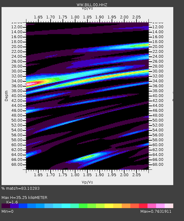
| Estimated Moho Depth: |
35.25 km |
| Estimated Crust Vp/Vs: |
1.60 |
| Assumed Crust Vp: |
6.571 km/s |
| Estimated Crust Vs: |
4.107 km/s |
| Estimated Crust Poisson's Ratio: |
0.18 |
|
| Radial Match: |
83.10283 % |
| Radial Bump: |
400 |
| Transverse Match: |
69.32262 % |
| Transverse Bump: |
400 |
| SOD ConfigId: |
28764291 |
| Insert Time: |
2022-10-01 14:08:07.126 +0000 |
| GWidth: |
2.5 |
| Max Bumps: |
400 |
| Tol: |
0.001 |
|
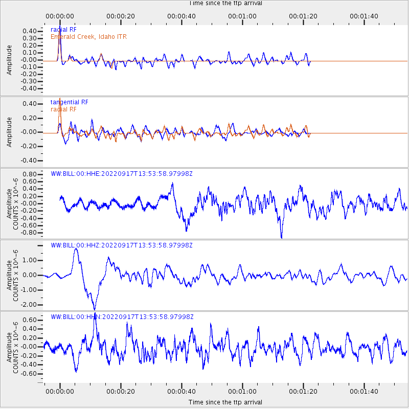
Signal To Noise
| Channel | StoN | STA | LTA |
| WW:BILL:00:HHZ:20220917T13:53:58.97998Z | 3.7242227 | 4.5458327E-7 | 1.2206125E-7 |
| WW:BILL:00:HHN:20220917T13:53:58.97998Z | 0.717745 | 1.0203363E-7 | 1.421586E-7 |
| WW:BILL:00:HHE:20220917T13:53:58.97998Z | 1.5343747 | 1.3847239E-7 | 9.0246786E-8 |
| Arrivals |
| Ps | 3.3 SECOND |
| PpPs | 14 SECOND |
| PsPs/PpSs | 17 SECOND |


