You are here: Home > Network List > AV - Alaska Volcano Observatory Stations List
> Station MAPS Pakushin Southeast, Makushin Volcano, Alaska > Earthquake Result Viewer
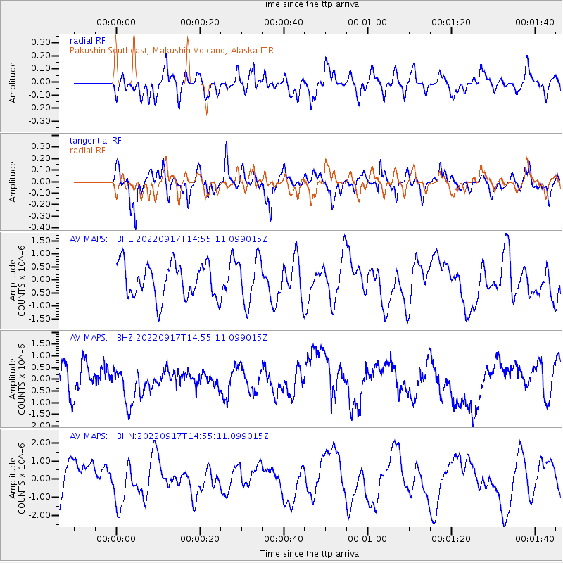
MAPS Pakushin Southeast, Makushin Volcano, Alaska - Earthquake Result Viewer
*The percent match for this event was below the threshold and hence no stack was calculated.
| Earthquake location: |
Taiwan Region |
| Earthquake latitude/longitude: |
23.0/121.2 |
| Earthquake time(UTC): |
2022/09/17 (260) 14:45:27 GMT |
| Earthquake Depth: |
10 km |
| Earthquake Magnitude: |
5.5 Mww |
| Earthquake Catalog/Contributor: |
NEIC PDE/us |
|
| Network: |
AV Alaska Volcano Observatory |
| Station: |
MAPS Pakushin Southeast, Makushin Volcano, Alaska |
| Lat/Lon: |
53.81 N/166.94 W |
| Elevation: |
333 m |
|
| Distance: |
61.1 deg |
| Az: |
40.053 deg |
| Baz: |
269.929 deg |
| Ray Param: |
$rayparam |
*The percent match for this event was below the threshold and hence was not used in the summary stack. |
|
| Radial Match: |
34.692783 % |
| Radial Bump: |
341 |
| Transverse Match: |
46.62209 % |
| Transverse Bump: |
400 |
| SOD ConfigId: |
28764291 |
| Insert Time: |
2022-10-01 14:51:49.516 +0000 |
| GWidth: |
2.5 |
| Max Bumps: |
400 |
| Tol: |
0.001 |
|
Signal To Noise
| Channel | StoN | STA | LTA |
| AV:MAPS: :BHZ:20220917T14:55:11.099015Z | 1.2299118 | 7.983293E-7 | 6.490947E-7 |
| AV:MAPS: :BHN:20220917T14:55:11.099015Z | 0.96930146 | 1.1384145E-6 | 1.1744689E-6 |
| AV:MAPS: :BHE:20220917T14:55:11.099015Z | 1.3110198 | 8.5808904E-7 | 6.545203E-7 |
| Arrivals |
| Ps | |
| PpPs | |
| PsPs/PpSs | |


