You are here: Home > Network List > US - United States National Seismic Network Stations List
> Station MSO Missoula, Montana, USA > Earthquake Result Viewer
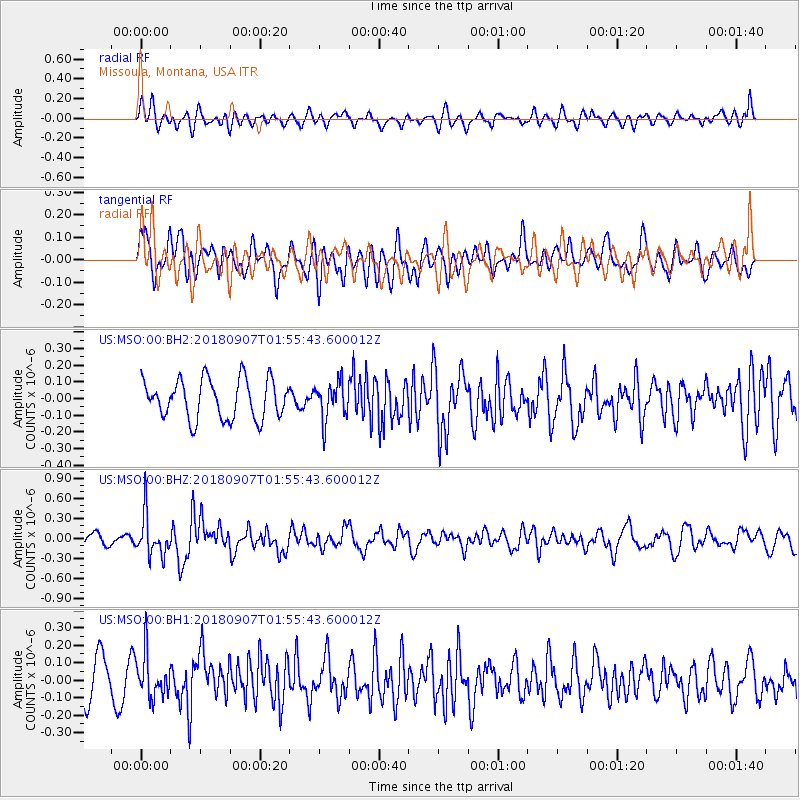
MSO Missoula, Montana, USA - Earthquake Result Viewer
*The percent match for this event was below the threshold and hence no stack was calculated.
| Earthquake location: |
Panama-Colombia Border Region |
| Earthquake latitude/longitude: |
8.0/-77.6 |
| Earthquake time(UTC): |
2018/09/07 (250) 01:47:23 GMT |
| Earthquake Depth: |
10 km |
| Earthquake Magnitude: |
5.6 mb |
| Earthquake Catalog/Contributor: |
NEIC PDE/us |
|
| Network: |
US United States National Seismic Network |
| Station: |
MSO Missoula, Montana, USA |
| Lat/Lon: |
46.83 N/113.94 W |
| Elevation: |
1264 m |
|
| Distance: |
49.5 deg |
| Az: |
327.68 deg |
| Baz: |
129.546 deg |
| Ray Param: |
$rayparam |
*The percent match for this event was below the threshold and hence was not used in the summary stack. |
|
| Radial Match: |
49.842346 % |
| Radial Bump: |
400 |
| Transverse Match: |
49.328957 % |
| Transverse Bump: |
400 |
| SOD ConfigId: |
2825771 |
| Insert Time: |
2018-09-21 02:06:13.019 +0000 |
| GWidth: |
2.5 |
| Max Bumps: |
400 |
| Tol: |
0.001 |
|
Signal To Noise
| Channel | StoN | STA | LTA |
| US:MSO:00:BHZ:20180907T01:55:43.600012Z | 2.9372451 | 3.0258764E-7 | 1.0301749E-7 |
| US:MSO:00:BH1:20180907T01:55:43.600012Z | 1.3023667 | 1.2458004E-7 | 9.565665E-8 |
| US:MSO:00:BH2:20180907T01:55:43.600012Z | 0.93956757 | 1.0946956E-7 | 1.1651058E-7 |
| Arrivals |
| Ps | |
| PpPs | |
| PsPs/PpSs | |


