You are here: Home > Network List > 1E - GSC-BCOGC Induced Seismicity Study Stations List
> Station MONT7 Z > Earthquake Result Viewer
MONT7 Z - Earthquake Result Viewer
| Earthquake location: |
Taiwan |
| Earthquake latitude/longitude: |
23.1/121.3 |
| Earthquake time(UTC): |
2022/09/18 (261) 06:44:15 GMT |
| Earthquake Depth: |
10 km |
| Earthquake Magnitude: |
7.2 Mi |
| Earthquake Catalog/Contributor: |
NEIC PDE/at |
|
| Network: |
1E GSC-BCOGC Induced Seismicity Study |
| Station: |
MONT7 Z |
| Lat/Lon: |
56.31 N/122.03 W |
| Elevation: |
797 m |
|
| Distance: |
84.6 deg |
| Az: |
30.014 deg |
| Baz: |
304.265 deg |
| Ray Param: |
0.04535087 |
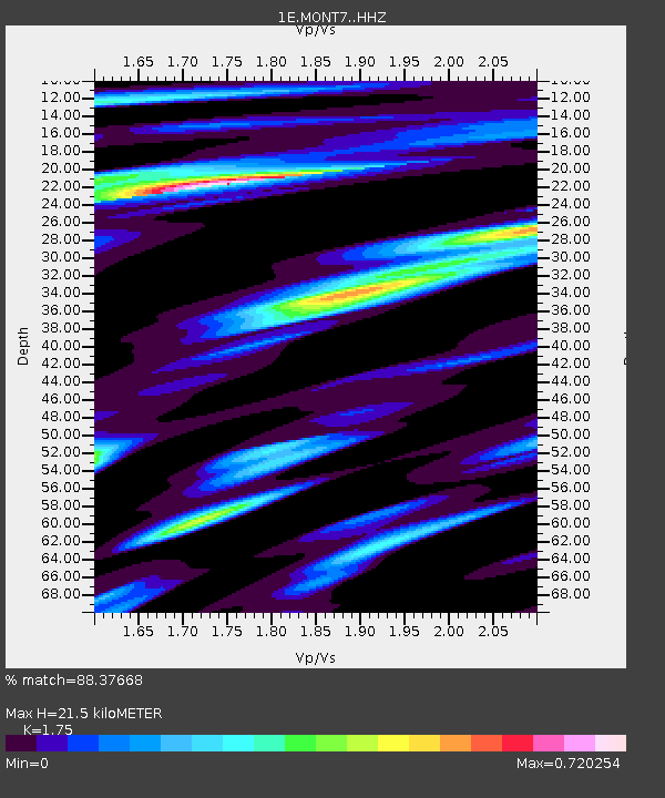
| Estimated Moho Depth: |
21.5 km |
| Estimated Crust Vp/Vs: |
1.75 |
| Assumed Crust Vp: |
6.232 km/s |
| Estimated Crust Vs: |
3.561 km/s |
| Estimated Crust Poisson's Ratio: |
0.26 |
|
| Radial Match: |
88.37668 % |
| Radial Bump: |
400 |
| Transverse Match: |
80.37065 % |
| Transverse Bump: |
400 |
| SOD ConfigId: |
28764291 |
| Insert Time: |
2022-10-02 06:45:54.740 +0000 |
| GWidth: |
2.5 |
| Max Bumps: |
400 |
| Tol: |
0.001 |
|

Signal To Noise
| Channel | StoN | STA | LTA |
| 1E:MONT7: :HHZ:20220918T06:56:17.130005Z | 4.712771 | 1.3860231E-6 | 2.940994E-7 |
| 1E:MONT7: :HHN:20220918T06:56:17.130005Z | 1.4900512 | 4.3673606E-7 | 2.9310138E-7 |
| 1E:MONT7: :HHE:20220918T06:56:17.130005Z | 1.6616248 | 4.225763E-7 | 2.5431513E-7 |
| Arrivals |
| Ps | 2.6 SECOND |
| PpPs | 9.3 SECOND |
| PsPs/PpSs | 12 SECOND |


