You are here: Home > Network List > AK - Alaska Regional Network Stations List
> Station B20K Meade River, AK, USA > Earthquake Result Viewer
B20K Meade River, AK, USA - Earthquake Result Viewer
| Earthquake location: |
Taiwan |
| Earthquake latitude/longitude: |
23.1/121.3 |
| Earthquake time(UTC): |
2022/09/18 (261) 06:44:15 GMT |
| Earthquake Depth: |
10 km |
| Earthquake Magnitude: |
7.2 Mi |
| Earthquake Catalog/Contributor: |
NEIC PDE/at |
|
| Network: |
AK Alaska Regional Network |
| Station: |
B20K Meade River, AK, USA |
| Lat/Lon: |
70.01 N/157.16 W |
| Elevation: |
75 m |
|
| Distance: |
65.6 deg |
| Az: |
21.932 deg |
| Baz: |
270.439 deg |
| Ray Param: |
0.058152262 |
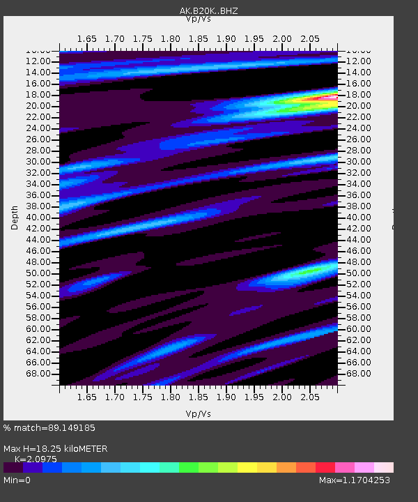
| Estimated Moho Depth: |
18.25 km |
| Estimated Crust Vp/Vs: |
2.10 |
| Assumed Crust Vp: |
6.048 km/s |
| Estimated Crust Vs: |
2.883 km/s |
| Estimated Crust Poisson's Ratio: |
0.35 |
|
| Radial Match: |
89.149185 % |
| Radial Bump: |
400 |
| Transverse Match: |
73.78645 % |
| Transverse Bump: |
400 |
| SOD ConfigId: |
28764291 |
| Insert Time: |
2022-10-02 06:46:37.055 +0000 |
| GWidth: |
2.5 |
| Max Bumps: |
400 |
| Tol: |
0.001 |
|

Signal To Noise
| Channel | StoN | STA | LTA |
| AK:B20K: :BHZ:20220918T06:54:27.859985Z | 4.9320116 | 2.3062257E-6 | 4.6760346E-7 |
| AK:B20K: :BHN:20220918T06:54:27.859985Z | 1.1857855 | 5.919517E-7 | 4.9920635E-7 |
| AK:B20K: :BHE:20220918T06:54:27.859985Z | 2.1454856 | 1.1042695E-6 | 5.1469436E-7 |
| Arrivals |
| Ps | 3.4 SECOND |
| PpPs | 9.1 SECOND |
| PsPs/PpSs | 12 SECOND |


