You are here: Home > Network List > AK - Alaska Regional Network Stations List
> Station D17K Noatak River, AK, USA > Earthquake Result Viewer
D17K Noatak River, AK, USA - Earthquake Result Viewer
| Earthquake location: |
Taiwan |
| Earthquake latitude/longitude: |
23.1/121.3 |
| Earthquake time(UTC): |
2022/09/18 (261) 06:44:15 GMT |
| Earthquake Depth: |
10 km |
| Earthquake Magnitude: |
7.2 Mi |
| Earthquake Catalog/Contributor: |
NEIC PDE/at |
|
| Network: |
AK Alaska Regional Network |
| Station: |
D17K Noatak River, AK, USA |
| Lat/Lon: |
67.70 N/163.08 W |
| Elevation: |
172 m |
|
| Distance: |
63.4 deg |
| Az: |
24.424 deg |
| Baz: |
265.99 deg |
| Ray Param: |
0.059612047 |
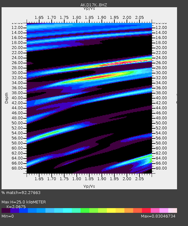
| Estimated Moho Depth: |
25.0 km |
| Estimated Crust Vp/Vs: |
2.07 |
| Assumed Crust Vp: |
6.276 km/s |
| Estimated Crust Vs: |
3.035 km/s |
| Estimated Crust Poisson's Ratio: |
0.35 |
|
| Radial Match: |
92.27663 % |
| Radial Bump: |
377 |
| Transverse Match: |
83.62186 % |
| Transverse Bump: |
400 |
| SOD ConfigId: |
28764291 |
| Insert Time: |
2022-10-02 06:47:19.655 +0000 |
| GWidth: |
2.5 |
| Max Bumps: |
400 |
| Tol: |
0.001 |
|

Signal To Noise
| Channel | StoN | STA | LTA |
| AK:D17K: :BHZ:20220918T06:54:13.380005Z | 3.3855047 | 2.5634954E-6 | 7.571974E-7 |
| AK:D17K: :BHN:20220918T06:54:13.380005Z | 1.1394726 | 6.6180513E-7 | 5.807995E-7 |
| AK:D17K: :BHE:20220918T06:54:13.380005Z | 1.5981297 | 1.121217E-6 | 7.0158075E-7 |
| Arrivals |
| Ps | 4.4 SECOND |
| PpPs | 12 SECOND |
| PsPs/PpSs | 16 SECOND |


