You are here: Home > Network List > AK - Alaska Regional Network Stations List
> Station F21K Alatna River, AK, USA > Earthquake Result Viewer
F21K Alatna River, AK, USA - Earthquake Result Viewer
| Earthquake location: |
Taiwan |
| Earthquake latitude/longitude: |
23.1/121.3 |
| Earthquake time(UTC): |
2022/09/18 (261) 06:44:15 GMT |
| Earthquake Depth: |
10 km |
| Earthquake Magnitude: |
7.2 Mi |
| Earthquake Catalog/Contributor: |
NEIC PDE/at |
|
| Network: |
AK Alaska Regional Network |
| Station: |
F21K Alatna River, AK, USA |
| Lat/Lon: |
67.22 N/153.48 W |
| Elevation: |
597 m |
|
| Distance: |
67.1 deg |
| Az: |
24.913 deg |
| Baz: |
275.056 deg |
| Ray Param: |
0.057180855 |
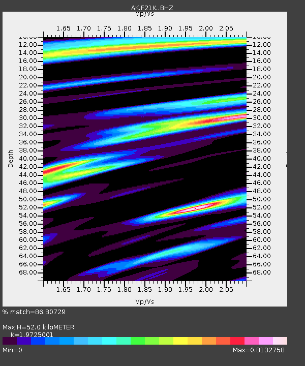
| Estimated Moho Depth: |
52.0 km |
| Estimated Crust Vp/Vs: |
1.97 |
| Assumed Crust Vp: |
6.455 km/s |
| Estimated Crust Vs: |
3.273 km/s |
| Estimated Crust Poisson's Ratio: |
0.33 |
|
| Radial Match: |
86.80729 % |
| Radial Bump: |
400 |
| Transverse Match: |
87.22995 % |
| Transverse Bump: |
400 |
| SOD ConfigId: |
28764291 |
| Insert Time: |
2022-10-02 06:47:41.352 +0000 |
| GWidth: |
2.5 |
| Max Bumps: |
400 |
| Tol: |
0.001 |
|

Signal To Noise
| Channel | StoN | STA | LTA |
| AK:F21K: :BHZ:20220918T06:54:37.340027Z | 7.868224 | 1.7721289E-6 | 2.2522605E-7 |
| AK:F21K: :BHN:20220918T06:54:37.340027Z | 0.9538064 | 1.680957E-7 | 1.7623671E-7 |
| AK:F21K: :BHE:20220918T06:54:37.340027Z | 6.8224034 | 8.1307644E-7 | 1.1917742E-7 |
| Arrivals |
| Ps | 8.1 SECOND |
| PpPs | 23 SECOND |
| PsPs/PpSs | 31 SECOND |


