You are here: Home > Network List > CC - Cascade Chain Volcano Monitoring Stations List
> Station CRBN Carbon River Ranger Station > Earthquake Result Viewer
CRBN Carbon River Ranger Station - Earthquake Result Viewer
| Earthquake location: |
Taiwan |
| Earthquake latitude/longitude: |
23.1/121.3 |
| Earthquake time(UTC): |
2022/09/18 (261) 06:44:15 GMT |
| Earthquake Depth: |
10 km |
| Earthquake Magnitude: |
7.2 Mi |
| Earthquake Catalog/Contributor: |
NEIC PDE/at |
|
| Network: |
CC Cascade Chain Volcano Monitoring |
| Station: |
CRBN Carbon River Ranger Station |
| Lat/Lon: |
46.99 N/121.96 W |
| Elevation: |
500 m |
|
| Distance: |
90.0 deg |
| Az: |
37.69 deg |
| Baz: |
304.684 deg |
| Ray Param: |
0.041727472 |
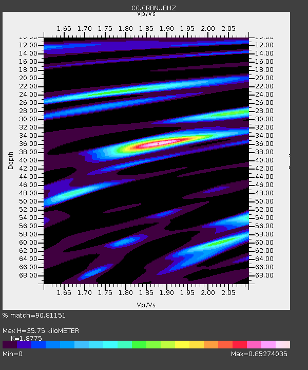
| Estimated Moho Depth: |
35.75 km |
| Estimated Crust Vp/Vs: |
1.88 |
| Assumed Crust Vp: |
6.597 km/s |
| Estimated Crust Vs: |
3.514 km/s |
| Estimated Crust Poisson's Ratio: |
0.30 |
|
| Radial Match: |
90.81151 % |
| Radial Bump: |
351 |
| Transverse Match: |
89.36237 % |
| Transverse Bump: |
400 |
| SOD ConfigId: |
28764291 |
| Insert Time: |
2022-10-02 06:55:20.128 +0000 |
| GWidth: |
2.5 |
| Max Bumps: |
400 |
| Tol: |
0.001 |
|

Signal To Noise
| Channel | StoN | STA | LTA |
| CC:CRBN: :BHZ:20220918T06:56:42.820007Z | 7.2508097 | 9.426898E-7 | 1.3001166E-7 |
| CC:CRBN: :BHN:20220918T06:56:42.820007Z | 1.2132581 | 1.8206124E-7 | 1.5005978E-7 |
| CC:CRBN: :BHE:20220918T06:56:42.820007Z | 1.894359 | 2.3544965E-7 | 1.2428988E-7 |
| Arrivals |
| Ps | 4.9 SECOND |
| PpPs | 15 SECOND |
| PsPs/PpSs | 20 SECOND |


