You are here: Home > Network List > CC - Cascade Chain Volcano Monitoring Stations List
> Station OPCH Ohanapecosh Administrative Area > Earthquake Result Viewer
OPCH Ohanapecosh Administrative Area - Earthquake Result Viewer
| Earthquake location: |
Taiwan |
| Earthquake latitude/longitude: |
23.1/121.3 |
| Earthquake time(UTC): |
2022/09/18 (261) 06:44:15 GMT |
| Earthquake Depth: |
10 km |
| Earthquake Magnitude: |
7.2 Mi |
| Earthquake Catalog/Contributor: |
NEIC PDE/at |
|
| Network: |
CC Cascade Chain Volcano Monitoring |
| Station: |
OPCH Ohanapecosh Administrative Area |
| Lat/Lon: |
46.73 N/121.57 W |
| Elevation: |
593 m |
|
| Distance: |
90.3 deg |
| Az: |
37.748 deg |
| Baz: |
304.967 deg |
| Ray Param: |
0.04171099 |
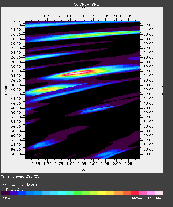
| Estimated Moho Depth: |
32.5 km |
| Estimated Crust Vp/Vs: |
1.83 |
| Assumed Crust Vp: |
6.597 km/s |
| Estimated Crust Vs: |
3.61 km/s |
| Estimated Crust Poisson's Ratio: |
0.29 |
|
| Radial Match: |
86.259705 % |
| Radial Bump: |
400 |
| Transverse Match: |
80.3523 % |
| Transverse Bump: |
400 |
| SOD ConfigId: |
28764291 |
| Insert Time: |
2022-10-02 06:55:34.285 +0000 |
| GWidth: |
2.5 |
| Max Bumps: |
400 |
| Tol: |
0.001 |
|

Signal To Noise
| Channel | StoN | STA | LTA |
| CC:OPCH: :BHZ:20220918T06:56:44.52002Z | 5.570793 | 8.0982045E-7 | 1.4536897E-7 |
| CC:OPCH: :BHN:20220918T06:56:44.52002Z | 0.8913463 | 2.442486E-7 | 2.7402214E-7 |
| CC:OPCH: :BHE:20220918T06:56:44.52002Z | 1.1827581 | 1.9699496E-7 | 1.6655558E-7 |
| Arrivals |
| Ps | 4.2 SECOND |
| PpPs | 14 SECOND |
| PsPs/PpSs | 18 SECOND |


