You are here: Home > Network List > AG - Arkansas Seismic Network Stations List
> Station WHAR Woolly Hollow State Park,AR > Earthquake Result Viewer
WHAR Woolly Hollow State Park,AR - Earthquake Result Viewer
| Earthquake location: |
Ecuador |
| Earthquake latitude/longitude: |
-2.3/-78.9 |
| Earthquake time(UTC): |
2018/09/07 (250) 02:12:04 GMT |
| Earthquake Depth: |
94 km |
| Earthquake Magnitude: |
6.2 Mww |
| Earthquake Catalog/Contributor: |
NEIC PDE/us |
|
| Network: |
AG Arkansas Seismic Network |
| Station: |
WHAR Woolly Hollow State Park,AR |
| Lat/Lon: |
35.29 N/92.29 W |
| Elevation: |
184 m |
|
| Distance: |
39.5 deg |
| Az: |
342.663 deg |
| Baz: |
158.656 deg |
| Ray Param: |
0.07464355 |
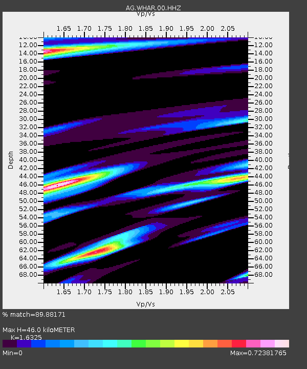
| Estimated Moho Depth: |
46.0 km |
| Estimated Crust Vp/Vs: |
1.63 |
| Assumed Crust Vp: |
6.498 km/s |
| Estimated Crust Vs: |
3.98 km/s |
| Estimated Crust Poisson's Ratio: |
0.20 |
|
| Radial Match: |
89.88171 % |
| Radial Bump: |
375 |
| Transverse Match: |
76.77959 % |
| Transverse Bump: |
400 |
| SOD ConfigId: |
2825771 |
| Insert Time: |
2018-09-21 02:25:32.844 +0000 |
| GWidth: |
2.5 |
| Max Bumps: |
400 |
| Tol: |
0.001 |
|

Signal To Noise
| Channel | StoN | STA | LTA |
| AG:WHAR:00:HHZ:20180907T02:18:55.304987Z | 24.011377 | 2.3563862E-6 | 9.813624E-8 |
| AG:WHAR:00:HHN:20180907T02:18:55.304987Z | 14.96925 | 1.3126256E-6 | 8.768813E-8 |
| AG:WHAR:00:HHE:20180907T02:18:55.304987Z | 8.116987 | 6.594293E-7 | 8.124065E-8 |
| Arrivals |
| Ps | 4.8 SECOND |
| PpPs | 17 SECOND |
| PsPs/PpSs | 22 SECOND |


