You are here: Home > Network List > AU - Australian Seismological Centre Stations List
> Station KIM02 GSWA station > Earthquake Result Viewer
KIM02 GSWA station - Earthquake Result Viewer
| Earthquake location: |
Taiwan |
| Earthquake latitude/longitude: |
23.2/121.3 |
| Earthquake time(UTC): |
2022/09/18 (261) 09:39:56 GMT |
| Earthquake Depth: |
10 km |
| Earthquake Magnitude: |
5.5 mb |
| Earthquake Catalog/Contributor: |
NEIC PDE/us |
|
| Network: |
AU Australian Seismological Centre |
| Station: |
KIM02 GSWA station |
| Lat/Lon: |
18.92 S/125.53 E |
| Elevation: |
150 m |
|
| Distance: |
42.1 deg |
| Az: |
174.018 deg |
| Baz: |
354.187 deg |
| Ray Param: |
0.07339594 |
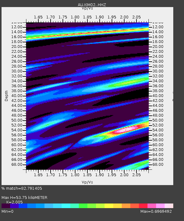
| Estimated Moho Depth: |
53.75 km |
| Estimated Crust Vp/Vs: |
2.01 |
| Assumed Crust Vp: |
6.337 km/s |
| Estimated Crust Vs: |
3.161 km/s |
| Estimated Crust Poisson's Ratio: |
0.33 |
|
| Radial Match: |
82.791405 % |
| Radial Bump: |
305 |
| Transverse Match: |
47.74055 % |
| Transverse Bump: |
400 |
| SOD ConfigId: |
28764291 |
| Insert Time: |
2022-10-02 09:45:29.585 +0000 |
| GWidth: |
2.5 |
| Max Bumps: |
400 |
| Tol: |
0.001 |
|

Signal To Noise
| Channel | StoN | STA | LTA |
| AU:KIM02: :HHZ:20220918T09:47:17.325013Z | 1.6632637 | 6.651218E-7 | 3.998896E-7 |
| AU:KIM02: :HHN:20220918T09:47:17.325013Z | 0.76903176 | 4.160337E-7 | 5.409838E-7 |
| AU:KIM02: :HHE:20220918T09:47:17.325013Z | 0.5366531 | 3.3245053E-7 | 6.1948873E-7 |
| Arrivals |
| Ps | 9.0 SECOND |
| PpPs | 24 SECOND |
| PsPs/PpSs | 33 SECOND |


