You are here: Home > Network List > GS - US Geological Survey Networks Stations List
> Station KAN09 Caldwell North Station > Earthquake Result Viewer
KAN09 Caldwell North Station - Earthquake Result Viewer

| Earthquake location: |
Ecuador |
| Earthquake latitude/longitude: |
-2.3/-78.9 |
| Earthquake time(UTC): |
2018/09/07 (250) 02:12:04 GMT |
| Earthquake Depth: |
94 km |
| Earthquake Magnitude: |
6.2 Mww |
| Earthquake Catalog/Contributor: |
NEIC PDE/us |
|
| Network: |
GS US Geological Survey Networks |
| Station: |
KAN09 Caldwell North Station |
| Lat/Lon: |
37.14 N/97.62 W |
| Elevation: |
371 m |
|
| Distance: |
43.0 deg |
| Az: |
337.89 deg |
| Baz: |
151.927 deg |
| Ray Param: |
0.07253502 |
| Estimated Moho Depth: |
44.0 km |
| Estimated Crust Vp/Vs: |
1.82 |
| Assumed Crust Vp: |
6.483 km/s |
| Estimated Crust Vs: |
3.557 km/s |
| Estimated Crust Poisson's Ratio: |
0.28 |
|
| Radial Match: |
92.60315 % |
| Radial Bump: |
400 |
| Transverse Match: |
58.129246 % |
| Transverse Bump: |
400 |
| SOD ConfigId: |
2825771 |
| Insert Time: |
2018-09-21 02:27:07.026 +0000 |
| GWidth: |
2.5 |
| Max Bumps: |
400 |
| Tol: |
0.001 |
|
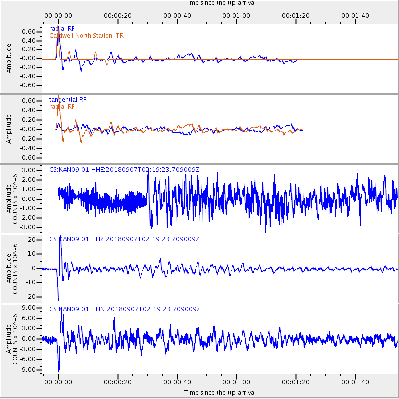
Signal To Noise
| Channel | StoN | STA | LTA |
| GS:KAN09:01:HHZ:20180907T02:19:23.709009Z | 42.54807 | 9.356939E-6 | 2.1991453E-7 |
| GS:KAN09:01:HHN:20180907T02:19:23.709009Z | 6.4049454 | 3.9738643E-6 | 6.204369E-7 |
| GS:KAN09:01:HHE:20180907T02:19:23.709009Z | 2.0677586 | 1.4911611E-6 | 7.211486E-7 |
| Arrivals |
| Ps | 6.0 SECOND |
| PpPs | 18 SECOND |
| PsPs/PpSs | 24 SECOND |


