You are here: Home > Network List > GT - Global Telemetered Seismograph Network (USAF/USGS) Stations List
> Station PLCA Paso Flores, Argentina > Earthquake Result Viewer
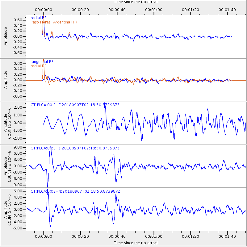
PLCA Paso Flores, Argentina - Earthquake Result Viewer
| Earthquake location: |
Ecuador |
| Earthquake latitude/longitude: |
-2.3/-78.9 |
| Earthquake time(UTC): |
2018/09/07 (250) 02:12:04 GMT |
| Earthquake Depth: |
94 km |
| Earthquake Magnitude: |
6.2 Mww |
| Earthquake Catalog/Contributor: |
NEIC PDE/us |
|
| Network: |
GT Global Telemetered Seismograph Network (USAF/USGS) |
| Station: |
PLCA Paso Flores, Argentina |
| Lat/Lon: |
40.73 S/70.55 W |
| Elevation: |
1050 m |
|
| Distance: |
39.0 deg |
| Az: |
169.896 deg |
| Baz: |
346.664 deg |
| Ray Param: |
0.074960254 |
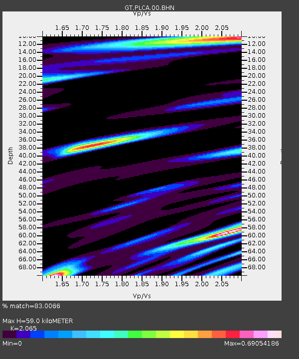
| Estimated Moho Depth: |
59.0 km |
| Estimated Crust Vp/Vs: |
2.07 |
| Assumed Crust Vp: |
6.597 km/s |
| Estimated Crust Vs: |
3.195 km/s |
| Estimated Crust Poisson's Ratio: |
0.35 |
|
| Radial Match: |
83.0066 % |
| Radial Bump: |
364 |
| Transverse Match: |
68.0776 % |
| Transverse Bump: |
400 |
| SOD ConfigId: |
2825771 |
| Insert Time: |
2018-09-21 02:27:37.910 +0000 |
| GWidth: |
2.5 |
| Max Bumps: |
400 |
| Tol: |
0.001 |
|
Signal To Noise
| Channel | StoN | STA | LTA |
| GT:PLCA:00:BHZ:20180907T02:18:50.873987Z | 9.452259 | 5.1515294E-6 | 5.450051E-7 |
| GT:PLCA:00:BHN:20180907T02:18:50.873987Z | 7.6651845 | 3.1450897E-6 | 4.1030842E-7 |
| GT:PLCA:00:BHE:20180907T02:18:50.873987Z | 1.3493191 | 1.0487164E-6 | 7.7721893E-7 |
| Arrivals |
| Ps | 10 SECOND |
| PpPs | 26 SECOND |
| PsPs/PpSs | 36 SECOND |


