You are here: Home > Network List > KO - Kandilli Observatory Digital Broadband Seismic Network Stations List
> Station GURO KO.GURO > Earthquake Result Viewer
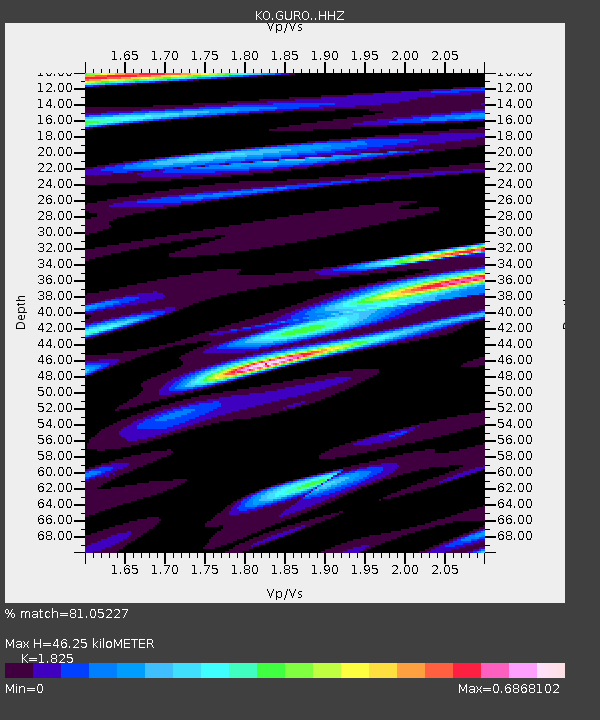
GURO KO.GURO - Earthquake Result Viewer
| Earthquake location: |
Taiwan |
| Earthquake latitude/longitude: |
23.4/121.4 |
| Earthquake time(UTC): |
2022/09/19 (262) 02:07:43 GMT |
| Earthquake Depth: |
13 km |
| Earthquake Magnitude: |
5.5 Mww |
| Earthquake Catalog/Contributor: |
NEIC PDE/us |
|
| Network: |
KO Kandilli Observatory Digital Broadband Seismic Network |
| Station: |
GURO KO.GURO |
| Lat/Lon: |
38.55 N/42.03 E |
| Elevation: |
1388 m |
|
| Distance: |
67.8 deg |
| Az: |
303.656 deg |
| Baz: |
77.236 deg |
| Ray Param: |
0.056726944 |
| Estimated Moho Depth: |
46.25 km |
| Estimated Crust Vp/Vs: |
1.83 |
| Assumed Crust Vp: |
6.35 km/s |
| Estimated Crust Vs: |
3.479 km/s |
| Estimated Crust Poisson's Ratio: |
0.29 |
|
| Radial Match: |
81.05227 % |
| Radial Bump: |
400 |
| Transverse Match: |
39.909763 % |
| Transverse Bump: |
400 |
| SOD ConfigId: |
28764291 |
| Insert Time: |
2022-10-03 02:22:31.819 +0000 |
| GWidth: |
2.5 |
| Max Bumps: |
400 |
| Tol: |
0.001 |
|

Signal To Noise
| Channel | StoN | STA | LTA |
| KO:GURO: :HHZ:20220919T02:18:10.090005Z | 5.6015396 | 2.8724875E-7 | 5.128032E-8 |
| KO:GURO: :HHN:20220919T02:18:10.090005Z | 1.2895275 | 1.7989628E-7 | 1.3950557E-7 |
| KO:GURO: :HHE:20220919T02:18:10.090005Z | 3.4941752 | 1.2548095E-7 | 3.5911466E-8 |
| Arrivals |
| Ps | 6.2 SECOND |
| PpPs | 20 SECOND |
| PsPs/PpSs | 26 SECOND |


