You are here: Home > Network List > AK - Alaska Regional Network Stations List
> Station BAGL Bagley Icefield, AK, USA > Earthquake Result Viewer
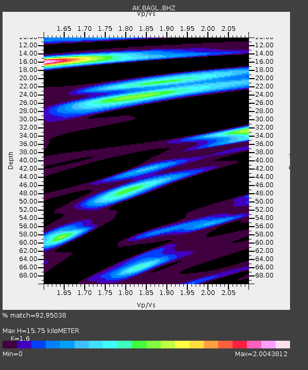
BAGL Bagley Icefield, AK, USA - Earthquake Result Viewer
| Earthquake location: |
Near Coast Of Michoacan, Mexico |
| Earthquake latitude/longitude: |
18.2/-103.4 |
| Earthquake time(UTC): |
2022/09/19 (262) 18:05:09 GMT |
| Earthquake Depth: |
10 km |
| Earthquake Magnitude: |
7.5 Mi |
| Earthquake Catalog/Contributor: |
NEIC PDE/at |
|
| Network: |
AK Alaska Regional Network |
| Station: |
BAGL Bagley Icefield, AK, USA |
| Lat/Lon: |
60.49 N/142.09 W |
| Elevation: |
1470 m |
|
| Distance: |
50.4 deg |
| Az: |
336.327 deg |
| Baz: |
129.563 deg |
| Ray Param: |
0.06806554 |
| Estimated Moho Depth: |
15.75 km |
| Estimated Crust Vp/Vs: |
1.60 |
| Assumed Crust Vp: |
6.566 km/s |
| Estimated Crust Vs: |
4.104 km/s |
| Estimated Crust Poisson's Ratio: |
0.18 |
|
| Radial Match: |
92.95038 % |
| Radial Bump: |
400 |
| Transverse Match: |
82.57564 % |
| Transverse Bump: |
400 |
| SOD ConfigId: |
28764291 |
| Insert Time: |
2022-10-03 18:08:10.682 +0000 |
| GWidth: |
2.5 |
| Max Bumps: |
400 |
| Tol: |
0.001 |
|

Signal To Noise
| Channel | StoN | STA | LTA |
| AK:BAGL: :BHZ:20220919T18:13:35.608002Z | 25.776012 | 9.118416E-6 | 3.5375587E-7 |
| AK:BAGL: :BHN:20220919T18:13:35.608002Z | 9.866189 | 2.553914E-6 | 2.5885518E-7 |
| AK:BAGL: :BHE:20220919T18:13:35.608002Z | 15.032008 | 3.2493283E-6 | 2.1616063E-7 |
| Arrivals |
| Ps | 1.5 SECOND |
| PpPs | 5.8 SECOND |
| PsPs/PpSs | 7.4 SECOND |


