You are here: Home > Network List > AK - Alaska Regional Network Stations List
> Station J17K VABM Dome, AK, USA > Earthquake Result Viewer
J17K VABM Dome, AK, USA - Earthquake Result Viewer
| Earthquake location: |
Near Coast Of Michoacan, Mexico |
| Earthquake latitude/longitude: |
18.2/-103.4 |
| Earthquake time(UTC): |
2022/09/19 (262) 18:05:09 GMT |
| Earthquake Depth: |
10 km |
| Earthquake Magnitude: |
7.5 Mi |
| Earthquake Catalog/Contributor: |
NEIC PDE/at |
|
| Network: |
AK Alaska Regional Network |
| Station: |
J17K VABM Dome, AK, USA |
| Lat/Lon: |
63.40 N/159.08 W |
| Elevation: |
323 m |
|
| Distance: |
58.8 deg |
| Az: |
334.224 deg |
| Baz: |
113.344 deg |
| Ray Param: |
0.06262752 |
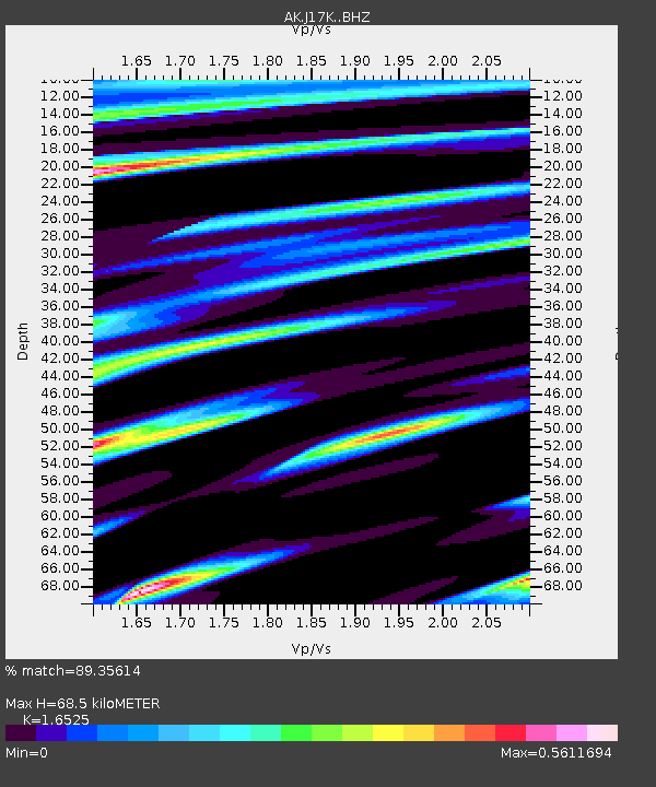
| Estimated Moho Depth: |
68.5 km |
| Estimated Crust Vp/Vs: |
1.65 |
| Assumed Crust Vp: |
6.276 km/s |
| Estimated Crust Vs: |
3.798 km/s |
| Estimated Crust Poisson's Ratio: |
0.21 |
|
| Radial Match: |
89.35614 % |
| Radial Bump: |
384 |
| Transverse Match: |
65.014565 % |
| Transverse Bump: |
400 |
| SOD ConfigId: |
28764291 |
| Insert Time: |
2022-10-03 18:10:03.210 +0000 |
| GWidth: |
2.5 |
| Max Bumps: |
400 |
| Tol: |
0.001 |
|

Signal To Noise
| Channel | StoN | STA | LTA |
| AK:J17K: :BHZ:20220919T18:14:36.039978Z | 45.911892 | 9.5799915E-6 | 2.0866035E-7 |
| AK:J17K: :BHN:20220919T18:14:36.039978Z | 11.934324 | 2.2255404E-6 | 1.8648231E-7 |
| AK:J17K: :BHE:20220919T18:14:36.039978Z | 28.381426 | 5.1608235E-6 | 1.8183806E-7 |
| Arrivals |
| Ps | 7.5 SECOND |
| PpPs | 28 SECOND |
| PsPs/PpSs | 35 SECOND |


