You are here: Home > Network List > NM - Cooperative New Madrid Seismic Network Stations List
> Station UTMT Martin, TN > Earthquake Result Viewer
UTMT Martin, TN - Earthquake Result Viewer
| Earthquake location: |
Ecuador |
| Earthquake latitude/longitude: |
-2.3/-78.9 |
| Earthquake time(UTC): |
2018/09/07 (250) 02:12:04 GMT |
| Earthquake Depth: |
94 km |
| Earthquake Magnitude: |
6.2 Mww |
| Earthquake Catalog/Contributor: |
NEIC PDE/us |
|
| Network: |
NM Cooperative New Madrid Seismic Network |
| Station: |
UTMT Martin, TN |
| Lat/Lon: |
36.35 N/88.86 W |
| Elevation: |
110 m |
|
| Distance: |
39.6 deg |
| Az: |
347.337 deg |
| Baz: |
164.257 deg |
| Ray Param: |
0.074571334 |
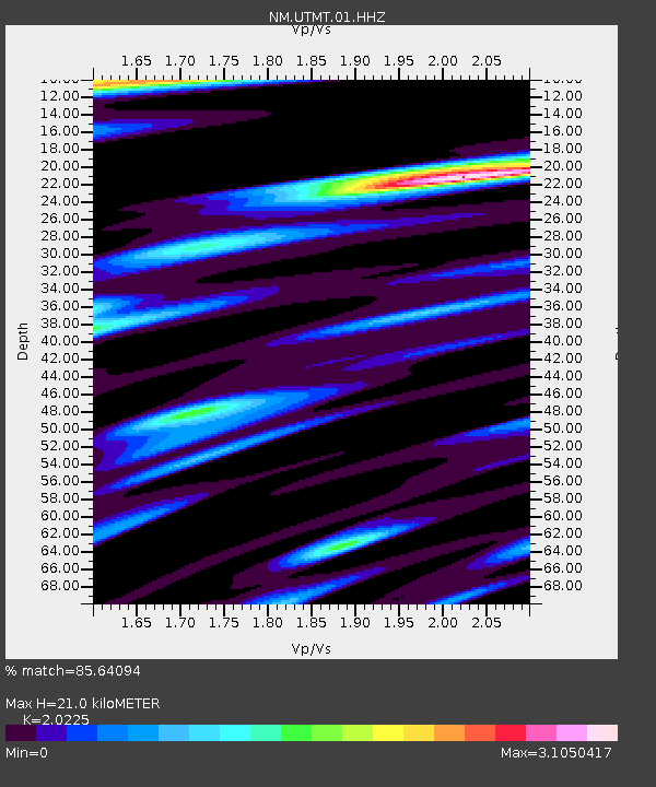
| Estimated Moho Depth: |
21.0 km |
| Estimated Crust Vp/Vs: |
2.02 |
| Assumed Crust Vp: |
6.444 km/s |
| Estimated Crust Vs: |
3.186 km/s |
| Estimated Crust Poisson's Ratio: |
0.34 |
|
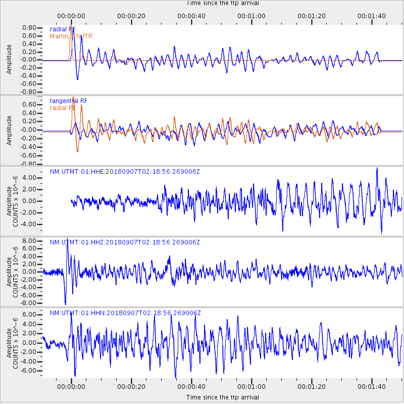
| Radial Match: |
85.64094 % |
| Radial Bump: |
400 |
| Transverse Match: |
76.39891 % |
| Transverse Bump: |
400 |
| SOD ConfigId: |
2825771 |
| Insert Time: |
2018-09-21 02:29:44.182 +0000 |
| GWidth: |
2.5 |
| Max Bumps: |
400 |
| Tol: |
0.001 |
|
Signal To Noise
| Channel | StoN | STA | LTA |
| NM:UTMT:01:HHZ:20180907T02:18:56.269006Z | 6.980532 | 2.2575648E-6 | 3.2340873E-7 |
| NM:UTMT:01:HHN:20180907T02:18:56.269006Z | 4.6977005 | 2.9946825E-6 | 6.3747837E-7 |
| NM:UTMT:01:HHE:20180907T02:18:56.269006Z | 2.1058307 | 1.1179159E-6 | 5.3086694E-7 |
| Arrivals |
| Ps | 3.5 SECOND |
| PpPs | 9.3 SECOND |
| PsPs/PpSs | 13 SECOND |


