You are here: Home > Network List > AT - Alaska Tsunami Warning Seismic System Stations List
> Station CHGN Chignik, Alaska > Earthquake Result Viewer
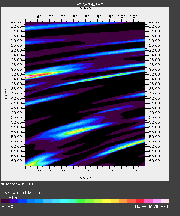
CHGN Chignik, Alaska - Earthquake Result Viewer
| Earthquake location: |
Near Coast Of Michoacan, Mexico |
| Earthquake latitude/longitude: |
18.2/-103.4 |
| Earthquake time(UTC): |
2022/09/19 (262) 18:05:09 GMT |
| Earthquake Depth: |
10 km |
| Earthquake Magnitude: |
7.5 Mi |
| Earthquake Catalog/Contributor: |
NEIC PDE/at |
|
| Network: |
AT Alaska Tsunami Warning Seismic System |
| Station: |
CHGN Chignik, Alaska |
| Lat/Lon: |
56.30 N/158.41 W |
| Elevation: |
17 m |
|
| Distance: |
55.8 deg |
| Az: |
326.501 deg |
| Baz: |
109.74 deg |
| Ray Param: |
0.06454461 |
| Estimated Moho Depth: |
33.0 km |
| Estimated Crust Vp/Vs: |
1.60 |
| Assumed Crust Vp: |
6.134 km/s |
| Estimated Crust Vs: |
3.834 km/s |
| Estimated Crust Poisson's Ratio: |
0.18 |
|
| Radial Match: |
89.18118 % |
| Radial Bump: |
310 |
| Transverse Match: |
81.72173 % |
| Transverse Bump: |
400 |
| SOD ConfigId: |
28764291 |
| Insert Time: |
2022-10-03 18:12:36.709 +0000 |
| GWidth: |
2.5 |
| Max Bumps: |
400 |
| Tol: |
0.001 |
|

Signal To Noise
| Channel | StoN | STA | LTA |
| AT:CHGN: :BHZ:20220919T18:14:15.400024Z | 39.5221 | 1.0380338E-5 | 2.626464E-7 |
| AT:CHGN: :BHN:20220919T18:14:15.400024Z | 1.17277 | 2.430718E-7 | 2.0726297E-7 |
| AT:CHGN: :BHE:20220919T18:14:15.400024Z | 20.375904 | 5.407054E-6 | 2.653651E-7 |
| Arrivals |
| Ps | 3.4 SECOND |
| PpPs | 13 SECOND |
| PsPs/PpSs | 17 SECOND |


