You are here: Home > Network List > AT - Alaska Tsunami Warning Seismic System Stations List
> Station TTA Tatalina, Alaska > Earthquake Result Viewer
TTA Tatalina, Alaska - Earthquake Result Viewer
| Earthquake location: |
Near Coast Of Michoacan, Mexico |
| Earthquake latitude/longitude: |
18.2/-103.4 |
| Earthquake time(UTC): |
2022/09/19 (262) 18:05:09 GMT |
| Earthquake Depth: |
10 km |
| Earthquake Magnitude: |
7.5 Mi |
| Earthquake Catalog/Contributor: |
NEIC PDE/at |
|
| Network: |
AT Alaska Tsunami Warning Seismic System |
| Station: |
TTA Tatalina, Alaska |
| Lat/Lon: |
62.93 N/156.01 W |
| Elevation: |
990 m |
|
| Distance: |
57.3 deg |
| Az: |
334.41 deg |
| Baz: |
116.175 deg |
| Ray Param: |
0.06358087 |
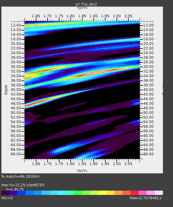
| Estimated Moho Depth: |
32.25 km |
| Estimated Crust Vp/Vs: |
1.92 |
| Assumed Crust Vp: |
6.182 km/s |
| Estimated Crust Vs: |
3.224 km/s |
| Estimated Crust Poisson's Ratio: |
0.31 |
|
| Radial Match: |
96.283844 % |
| Radial Bump: |
267 |
| Transverse Match: |
81.157906 % |
| Transverse Bump: |
400 |
| SOD ConfigId: |
28764291 |
| Insert Time: |
2022-10-03 18:12:50.068 +0000 |
| GWidth: |
2.5 |
| Max Bumps: |
400 |
| Tol: |
0.001 |
|

Signal To Noise
| Channel | StoN | STA | LTA |
| AT:TTA: :BHZ:20220919T18:14:25.840027Z | 51.370003 | 1.16761385E-5 | 2.2729486E-7 |
| AT:TTA: :BHN:20220919T18:14:25.840027Z | 10.340867 | 3.665041E-6 | 3.54423E-7 |
| AT:TTA: :BHE:20220919T18:14:25.840027Z | 21.958286 | 5.2793957E-6 | 2.4042842E-7 |
| Arrivals |
| Ps | 5.0 SECOND |
| PpPs | 15 SECOND |
| PsPs/PpSs | 20 SECOND |


