You are here: Home > Network List > AV - Alaska Volcano Observatory Stations List
> Station P19K Oil Pt, AK, USA > Earthquake Result Viewer
P19K Oil Pt, AK, USA - Earthquake Result Viewer
| Earthquake location: |
Near Coast Of Michoacan, Mexico |
| Earthquake latitude/longitude: |
18.2/-103.4 |
| Earthquake time(UTC): |
2022/09/19 (262) 18:05:09 GMT |
| Earthquake Depth: |
10 km |
| Earthquake Magnitude: |
7.5 Mi |
| Earthquake Catalog/Contributor: |
NEIC PDE/at |
|
| Network: |
AV Alaska Volcano Observatory |
| Station: |
P19K Oil Pt, AK, USA |
| Lat/Lon: |
59.65 N/153.23 W |
| Elevation: |
629 m |
|
| Distance: |
54.6 deg |
| Az: |
331.587 deg |
| Baz: |
117.03 deg |
| Ray Param: |
0.06532848 |
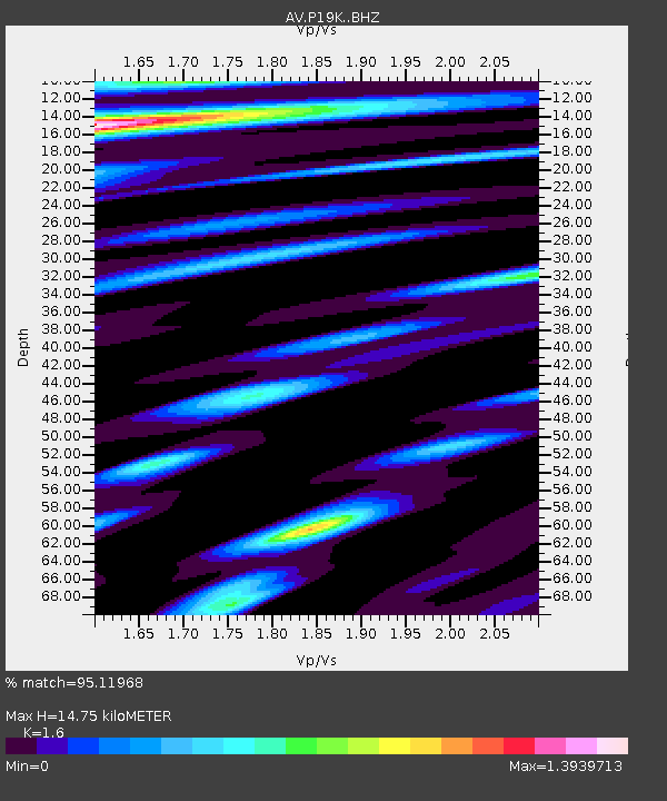
| Estimated Moho Depth: |
14.75 km |
| Estimated Crust Vp/Vs: |
1.60 |
| Assumed Crust Vp: |
5.989 km/s |
| Estimated Crust Vs: |
3.743 km/s |
| Estimated Crust Poisson's Ratio: |
0.18 |
|
| Radial Match: |
95.11968 % |
| Radial Bump: |
400 |
| Transverse Match: |
87.21199 % |
| Transverse Bump: |
400 |
| SOD ConfigId: |
28764291 |
| Insert Time: |
2022-10-03 18:13:54.268 +0000 |
| GWidth: |
2.5 |
| Max Bumps: |
400 |
| Tol: |
0.001 |
|

Signal To Noise
| Channel | StoN | STA | LTA |
| AV:P19K: :BHZ:20220919T18:14:06.724976Z | 35.068577 | 1.2881762E-5 | 3.6733064E-7 |
| AV:P19K: :BHN:20220919T18:14:06.724976Z | 5.909379 | 2.4403334E-6 | 4.129594E-7 |
| AV:P19K: :BHE:20220919T18:14:06.724976Z | 12.138415 | 5.0033664E-6 | 4.1219272E-7 |
| Arrivals |
| Ps | 1.6 SECOND |
| PpPs | 6.1 SECOND |
| PsPs/PpSs | 7.6 SECOND |


