You are here: Home > Network List > AV - Alaska Volcano Observatory Stations List
> Station PLK2 Mt. Peulik Volcano 2, Alaska > Earthquake Result Viewer
PLK2 Mt. Peulik Volcano 2, Alaska - Earthquake Result Viewer
| Earthquake location: |
Near Coast Of Michoacan, Mexico |
| Earthquake latitude/longitude: |
18.2/-103.4 |
| Earthquake time(UTC): |
2022/09/19 (262) 18:05:09 GMT |
| Earthquake Depth: |
10 km |
| Earthquake Magnitude: |
7.5 Mi |
| Earthquake Catalog/Contributor: |
NEIC PDE/at |
|
| Network: |
AV Alaska Volcano Observatory |
| Station: |
PLK2 Mt. Peulik Volcano 2, Alaska |
| Lat/Lon: |
57.76 N/156.33 W |
| Elevation: |
401 m |
|
| Distance: |
55.3 deg |
| Az: |
328.659 deg |
| Baz: |
112.709 deg |
| Ray Param: |
0.06488194 |
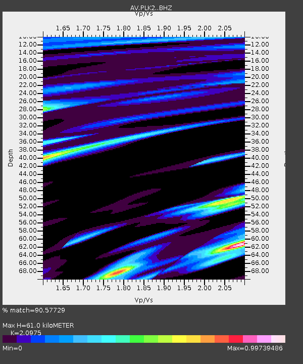
| Estimated Moho Depth: |
61.0 km |
| Estimated Crust Vp/Vs: |
2.10 |
| Assumed Crust Vp: |
6.1 km/s |
| Estimated Crust Vs: |
2.908 km/s |
| Estimated Crust Poisson's Ratio: |
0.35 |
|
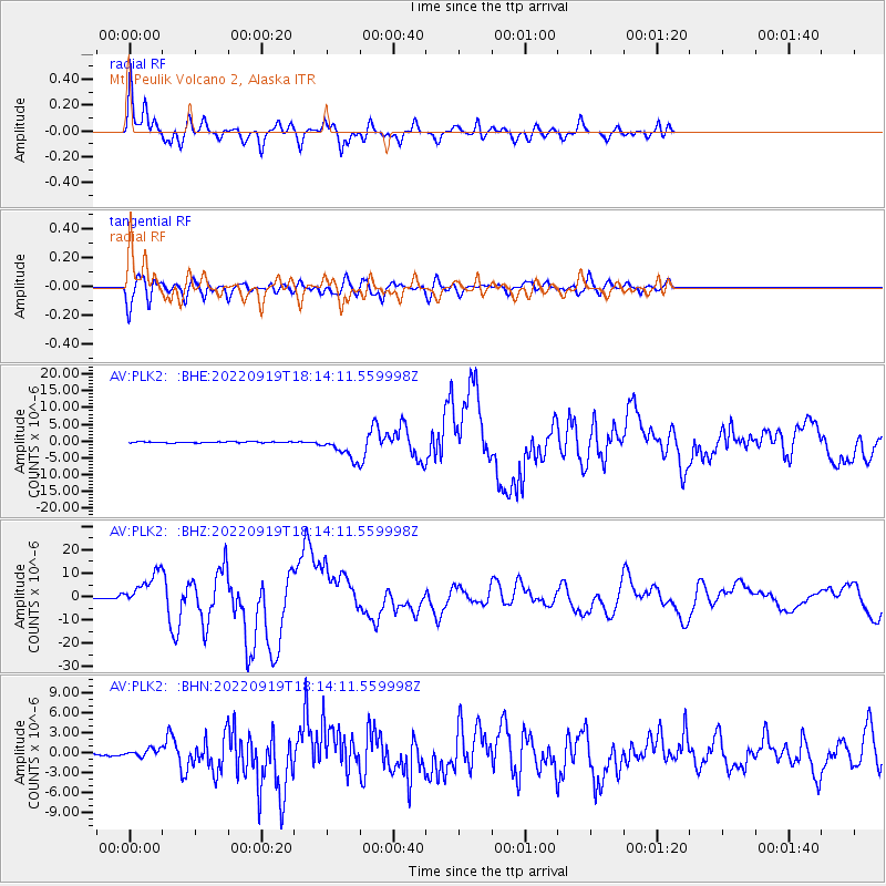
| Radial Match: |
90.57729 % |
| Radial Bump: |
350 |
| Transverse Match: |
80.8979 % |
| Transverse Bump: |
400 |
| SOD ConfigId: |
28764291 |
| Insert Time: |
2022-10-03 18:13:57.794 +0000 |
| GWidth: |
2.5 |
| Max Bumps: |
400 |
| Tol: |
0.001 |
|
Signal To Noise
| Channel | StoN | STA | LTA |
| AV:PLK2: :BHZ:20220919T18:14:11.559998Z | 35.85281 | 7.256016E-6 | 2.0238348E-7 |
| AV:PLK2: :BHN:20220919T18:14:11.559998Z | 3.2308433 | 5.972429E-7 | 1.8485666E-7 |
| AV:PLK2: :BHE:20220919T18:14:11.559998Z | 21.845877 | 3.4663813E-6 | 1.586744E-7 |
| Arrivals |
| Ps | 11 SECOND |
| PpPs | 30 SECOND |
| PsPs/PpSs | 41 SECOND |


