You are here: Home > Network List > AV - Alaska Volcano Observatory Stations List
> Station SPNN North Nagishlamina, Mount Spurr, Alaska > Earthquake Result Viewer
SPNN North Nagishlamina, Mount Spurr, Alaska - Earthquake Result Viewer
| Earthquake location: |
Near Coast Of Michoacan, Mexico |
| Earthquake latitude/longitude: |
18.2/-103.4 |
| Earthquake time(UTC): |
2022/09/19 (262) 18:05:09 GMT |
| Earthquake Depth: |
10 km |
| Earthquake Magnitude: |
7.5 Mi |
| Earthquake Catalog/Contributor: |
NEIC PDE/at |
|
| Network: |
AV Alaska Volcano Observatory |
| Station: |
SPNN North Nagishlamina, Mount Spurr, Alaska |
| Lat/Lon: |
61.37 N/152.70 W |
| Elevation: |
1666 m |
|
| Distance: |
55.2 deg |
| Az: |
333.595 deg |
| Baz: |
118.645 deg |
| Ray Param: |
0.06494932 |
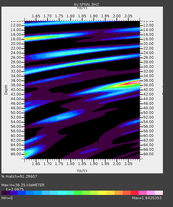
| Estimated Moho Depth: |
36.25 km |
| Estimated Crust Vp/Vs: |
2.10 |
| Assumed Crust Vp: |
6.566 km/s |
| Estimated Crust Vs: |
3.13 km/s |
| Estimated Crust Poisson's Ratio: |
0.35 |
|
| Radial Match: |
91.29607 % |
| Radial Bump: |
400 |
| Transverse Match: |
80.626564 % |
| Transverse Bump: |
400 |
| SOD ConfigId: |
28764291 |
| Insert Time: |
2022-10-03 18:14:24.906 +0000 |
| GWidth: |
2.5 |
| Max Bumps: |
400 |
| Tol: |
0.001 |
|

Signal To Noise
| Channel | StoN | STA | LTA |
| AV:SPNN: :BHZ:20220919T18:14:10.859985Z | 46.81516 | 7.0063356E-6 | 1.4965956E-7 |
| AV:SPNN: :BHN:20220919T18:14:10.859985Z | 16.798683 | 1.6519224E-6 | 9.833642E-8 |
| AV:SPNN: :BHE:20220919T18:14:10.859985Z | 26.224812 | 2.6809673E-6 | 1.0223019E-7 |
| Arrivals |
| Ps | 6.3 SECOND |
| PpPs | 16 SECOND |
| PsPs/PpSs | 23 SECOND |


