You are here: Home > Network List > AV - Alaska Volcano Observatory Stations List
> Station ILNE Iliamna Northeast, Iliamna, Alaska > Earthquake Result Viewer
ILNE Iliamna Northeast, Iliamna, Alaska - Earthquake Result Viewer
| Earthquake location: |
Near Coast Of Michoacan, Mexico |
| Earthquake latitude/longitude: |
18.2/-103.4 |
| Earthquake time(UTC): |
2022/09/19 (262) 18:05:09 GMT |
| Earthquake Depth: |
10 km |
| Earthquake Magnitude: |
7.5 Mi |
| Earthquake Catalog/Contributor: |
NEIC PDE/at |
|
| Network: |
AV Alaska Volcano Observatory |
| Station: |
ILNE Iliamna Northeast, Iliamna, Alaska |
| Lat/Lon: |
60.06 N/153.06 W |
| Elevation: |
1614 m |
|
| Distance: |
54.7 deg |
| Az: |
332.078 deg |
| Baz: |
117.459 deg |
| Ray Param: |
0.06525738 |
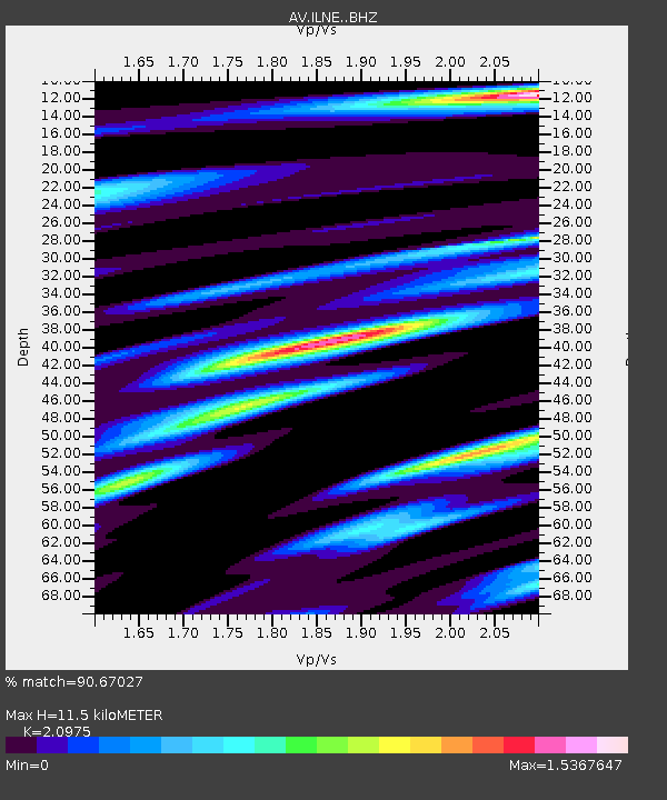
| Estimated Moho Depth: |
11.5 km |
| Estimated Crust Vp/Vs: |
2.10 |
| Assumed Crust Vp: |
6.566 km/s |
| Estimated Crust Vs: |
3.13 km/s |
| Estimated Crust Poisson's Ratio: |
0.35 |
|
| Radial Match: |
90.67027 % |
| Radial Bump: |
400 |
| Transverse Match: |
85.887085 % |
| Transverse Bump: |
400 |
| SOD ConfigId: |
28764291 |
| Insert Time: |
2022-10-03 18:14:38.168 +0000 |
| GWidth: |
2.5 |
| Max Bumps: |
400 |
| Tol: |
0.001 |
|

Signal To Noise
| Channel | StoN | STA | LTA |
| AV:ILNE: :BHZ:20220919T18:14:07.539978Z | 50.545227 | 6.9976986E-6 | 1.384443E-7 |
| AV:ILNE: :BHN:20220919T18:14:07.539978Z | 15.76582 | 2.1659198E-6 | 1.3738072E-7 |
| AV:ILNE: :BHE:20220919T18:14:07.539978Z | 18.074024 | 3.6111624E-6 | 1.9979848E-7 |
| Arrivals |
| Ps | 2.0 SECOND |
| PpPs | 5.2 SECOND |
| PsPs/PpSs | 7.2 SECOND |


