You are here: Home > Network List > AV - Alaska Volcano Observatory Stations List
> Station ANRM Aniakchak Rim, Alaska > Earthquake Result Viewer
ANRM Aniakchak Rim, Alaska - Earthquake Result Viewer

| Earthquake location: |
Near Coast Of Michoacan, Mexico |
| Earthquake latitude/longitude: |
18.2/-103.4 |
| Earthquake time(UTC): |
2022/09/19 (262) 18:05:09 GMT |
| Earthquake Depth: |
10 km |
| Earthquake Magnitude: |
7.5 Mi |
| Earthquake Catalog/Contributor: |
NEIC PDE/at |
|
| Network: |
AV Alaska Volcano Observatory |
| Station: |
ANRM Aniakchak Rim, Alaska |
| Lat/Lon: |
56.90 N/158.23 W |
| Elevation: |
1037 m |
|
| Distance: |
55.9 deg |
| Az: |
327.219 deg |
| Baz: |
110.293 deg |
| Ray Param: |
0.064474076 |
| Estimated Moho Depth: |
12.25 km |
| Estimated Crust Vp/Vs: |
1.87 |
| Assumed Crust Vp: |
6.134 km/s |
| Estimated Crust Vs: |
3.276 km/s |
| Estimated Crust Poisson's Ratio: |
0.30 |
|
| Radial Match: |
93.435104 % |
| Radial Bump: |
400 |
| Transverse Match: |
92.290215 % |
| Transverse Bump: |
400 |
| SOD ConfigId: |
28764291 |
| Insert Time: |
2022-10-03 18:14:43.336 +0000 |
| GWidth: |
2.5 |
| Max Bumps: |
400 |
| Tol: |
0.001 |
|
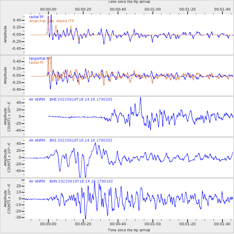
Signal To Noise
| Channel | StoN | STA | LTA |
| AV:ANRM: :BHZ:20220919T18:14:16.179016Z | 36.39289 | 1.1848274E-5 | 3.2556562E-7 |
| AV:ANRM: :BHN:20220919T18:14:16.179016Z | 5.5589223 | 2.4150272E-6 | 4.344416E-7 |
| AV:ANRM: :BHE:20220919T18:14:16.179016Z | 4.5816374 | 5.071938E-6 | 1.1070143E-6 |
| Arrivals |
| Ps | 1.8 SECOND |
| PpPs | 5.5 SECOND |
| PsPs/PpSs | 7.3 SECOND |


