You are here: Home > Network List > CC - Cascade Chain Volcano Monitoring Stations List
> Station LOO Loowit > Earthquake Result Viewer
LOO Loowit - Earthquake Result Viewer
| Earthquake location: |
Near Coast Of Michoacan, Mexico |
| Earthquake latitude/longitude: |
18.2/-103.4 |
| Earthquake time(UTC): |
2022/09/19 (262) 18:05:09 GMT |
| Earthquake Depth: |
10 km |
| Earthquake Magnitude: |
7.5 Mi |
| Earthquake Catalog/Contributor: |
NEIC PDE/at |
|
| Network: |
CC Cascade Chain Volcano Monitoring |
| Station: |
LOO Loowit |
| Lat/Lon: |
46.22 N/122.18 W |
| Elevation: |
1521 m |
|
| Distance: |
32.0 deg |
| Az: |
335.031 deg |
| Baz: |
144.692 deg |
| Ray Param: |
0.078862615 |
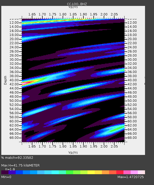
| Estimated Moho Depth: |
41.75 km |
| Estimated Crust Vp/Vs: |
1.60 |
| Assumed Crust Vp: |
6.566 km/s |
| Estimated Crust Vs: |
4.104 km/s |
| Estimated Crust Poisson's Ratio: |
0.18 |
|
| Radial Match: |
92.33582 % |
| Radial Bump: |
400 |
| Transverse Match: |
78.19323 % |
| Transverse Bump: |
400 |
| SOD ConfigId: |
28764291 |
| Insert Time: |
2022-10-03 18:17:28.186 +0000 |
| GWidth: |
2.5 |
| Max Bumps: |
400 |
| Tol: |
0.001 |
|

Signal To Noise
| Channel | StoN | STA | LTA |
| CC:LOO: :BHZ:20220919T18:11:04.459991Z | 37.27482 | 1.2372376E-5 | 3.3192316E-7 |
| CC:LOO: :BHN:20220919T18:11:04.459991Z | 5.046501 | 2.651709E-6 | 5.25455E-7 |
| CC:LOO: :BHE:20220919T18:11:04.459991Z | 14.735505 | 8.3761E-6 | 5.6842975E-7 |
| Arrivals |
| Ps | 4.2 SECOND |
| PpPs | 15 SECOND |
| PsPs/PpSs | 19 SECOND |


