You are here: Home > Network List > CN - Canadian National Seismograph Network Stations List
> Station INK INUVIK, NT > Earthquake Result Viewer
INK INUVIK, NT - Earthquake Result Viewer
| Earthquake location: |
Near Coast Of Michoacan, Mexico |
| Earthquake latitude/longitude: |
18.2/-103.4 |
| Earthquake time(UTC): |
2022/09/19 (262) 18:05:09 GMT |
| Earthquake Depth: |
10 km |
| Earthquake Magnitude: |
7.5 Mi |
| Earthquake Catalog/Contributor: |
NEIC PDE/at |
|
| Network: |
CN Canadian National Seismograph Network |
| Station: |
INK INUVIK, NT |
| Lat/Lon: |
68.31 N/133.53 W |
| Elevation: |
44 m |
|
| Distance: |
53.6 deg |
| Az: |
346.589 deg |
| Baz: |
143.63 deg |
| Ray Param: |
0.06602492 |
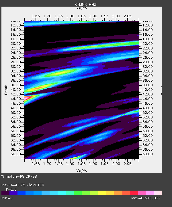
| Estimated Moho Depth: |
43.75 km |
| Estimated Crust Vp/Vs: |
1.60 |
| Assumed Crust Vp: |
6.171 km/s |
| Estimated Crust Vs: |
3.857 km/s |
| Estimated Crust Poisson's Ratio: |
0.18 |
|
| Radial Match: |
98.29798 % |
| Radial Bump: |
170 |
| Transverse Match: |
77.230995 % |
| Transverse Bump: |
400 |
| SOD ConfigId: |
28764291 |
| Insert Time: |
2022-10-03 18:19:05.949 +0000 |
| GWidth: |
2.5 |
| Max Bumps: |
400 |
| Tol: |
0.001 |
|
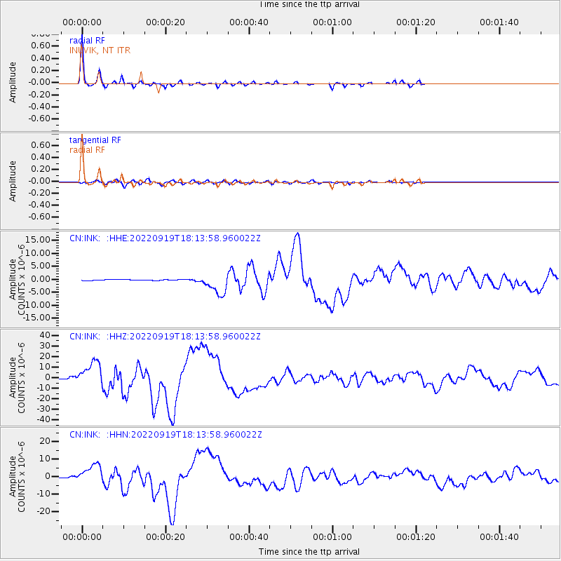
Signal To Noise
| Channel | StoN | STA | LTA |
| CN:INK: :HHZ:20220919T18:13:58.960022Z | 41.089268 | 1.2226621E-5 | 2.975624E-7 |
| CN:INK: :HHN:20220919T18:13:58.960022Z | 30.420227 | 5.717487E-6 | 1.8795018E-7 |
| CN:INK: :HHE:20220919T18:13:58.960022Z | 25.254705 | 4.2459687E-6 | 1.6812585E-7 |
| Arrivals |
| Ps | 4.5 SECOND |
| PpPs | 17 SECOND |
| PsPs/PpSs | 22 SECOND |


